Fretwell, Peter  ORCID: https://orcid.org/0000-0002-1988-5844.
2013
BEDMAP2: Bedrock topography of Antarctica.
BAS Thematic map series.
Cambridge, UK, British Antarctic Survey.
ORCID: https://orcid.org/0000-0002-1988-5844.
2013
BEDMAP2: Bedrock topography of Antarctica.
BAS Thematic map series.
Cambridge, UK, British Antarctic Survey.
Abstract
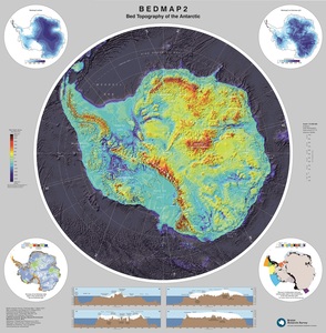
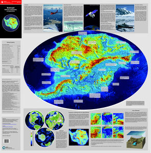
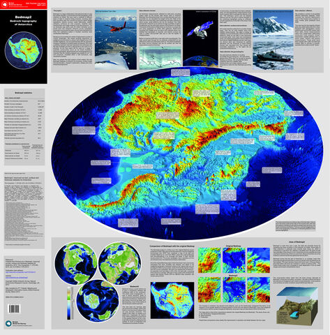
This map presents the final outputs from the BEDMAP2 project as a double-sided poster map.It shows the new BEDMAP datasets of Antarctic ice thickness, surface height and bed elevation mapped in planimetric, oblique and cross-sectional perspectives, and highlights some of the key geological and glaciological features revealed by the new datasets.
Documents
501469:264008
![[thumbnail of Open access]](https://nora.nerc.ac.uk/id/eprint/501469/1/Bedmap2%20side%201%20jpeg.jpg "Open access")
Preview
Open access
Bedmap2 side 1 jpeg.jpg - Published Version
Available under License Open Government Licence v3.
Bedmap2 side 1 jpeg.jpg - Published Version
Available under License Open Government Licence v3.
Download (3MB) | Preview
501469:264009
![[thumbnail of Open access]](https://nora.nerc.ac.uk/id/eprint/501469/2/Bedmap2%20side%202%20jpeg.jpg "Open access")
Preview
Open access
Bedmap2 side 2 jpeg.jpg - Published Version
Available under License Open Government Licence v3.
Bedmap2 side 2 jpeg.jpg - Published Version
Available under License Open Government Licence v3.
Download (5MB) | Preview
501469:264010
Preview
Open access
Bedmap2 side 1.pdf - Published Version
Available under License Open Government Licence v3.
Bedmap2 side 1.pdf - Published Version
Available under License Open Government Licence v3.
Download (122MB) | Preview
501469:264011
Preview
Open Access
Bedmap2 side 2.pdf - Published Version
Available under License Open Government Licence v3.
Bedmap2 side 2.pdf - Published Version
Available under License Open Government Licence v3.
Download (57MB) | Preview
Before downloading, please read NORA policies.
Information
Programmes:
BAS Programmes 2012 > Organisational
Library
Statistics
Downloads per month over past year
Share


 |