
a) The Central American poleward Low Level Jet (M. Nicolini, J. Paegle)
The LLJ in central South America plays an important role in the:
These three main aspects have been partially recognized in previous work mainly devoted to identify this phenomenon using different sources of information. If LLJs are classified as meso beta scale motions (typically with space scales between 20 and 200 km and limited to the lowest 2 km of the atmosphere), where strong diurnal oscillations and nocturnal accelerations are present in the current radiosounding network.
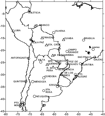
Fig. 5: Distribution of the rawinsonde network over South America over the geographical region where the low level jet occurs. identifies current sounding stations, represents tentative locations of proposed sounding sites.
There is a generalized idea that this low level jet structure is similar to its North American counterpart (Great Plains LLJ), observed by Bonner (1968) and others (see Fig. 4). This LLJ has been characterized and its role in the continental-scale water vapour budget has been presented by Helfand and Schubert (1995) using a GCM and by Berbery and Rasmusson (1996) using the high resolution ETA regional model. Confidence in these results has motivated the use of the ETA forecast products with a horizontal resolution of 40 km to characterize the structure and diurnal variability of the Central South America LLJ during the 1997-1998 warm season. Again, this representation cannot be verified by observations. This work also identifies other low level jet cases in the region, describes the relation between the convergence and precipitation patterns, characterizes the water vapour flux pattern, its diurnal variation and estimate the contribution of the low level jet to the convergence of the vertically integrated total fluxes in a domain covering the Paraná- Río de la Plata Basin.

Fig. 3a: Mean northerly wind field for December 1997 at 900 hPa and 06:00 UTC from the high resolution ETA forecast products.
Fig. 3b: Monthly average longitudinal cross section along 18oS and at 06:00 UTC of the meridional water vapour flux for December 1997 from the high resolution ETA forecast products.
Figure 3a displays the mean northerly wind field for December 1997 at the level and time corresponding to the occurrence of the maximum. The area that verifies the LLJ criterion is located in a data void region. Figure 5 includes tentative locations of the proposed sounding sites within this area, in order to enhance the current South American rawinsonde network. Figure 3b displays a monthly average longitudinal vertical cross section along 18oS of the meridional water vapour flux for December 1997. This vertical section shows a meridional water vapour flux with a strong magnitude and a dominant poleward direction downwind of the Andes in a latitude just to the south of the Amazon Basin. This is relevant to the analysis of the atmospheric branch of the hydrological cycle both over the Amazonia and the Paraná-Río de la Plata Basin. A question that persists is whether the LLJ is a real feature or an artifact of model deficiencies associated mainly with the representation of the steep Andes. Studies at Resistencia (Berri and Inzunza, 1993) and a recent short period of pilot balloon observations at Santa Cruz, Bolivia (Douglas, personal communication) give evidence of its existence. A field programme effort to describe adequately its structure and variability in different time scales is recommended. This field experiment should contribute to answer the questions posed in the VAMOS document (see section 3.4.7 of this document). It should also determine the evolution of the LLJ during intraseasonal wet and dry episodes over the subtropical plains and the remote and local influences associated with this evolution. As a monitoring system of the low-level circulation, a field experiment on this LLJ, should have linkages with other programmes centred in understanding the rainfall regimes in the Bolivian lowlands and the Altiplano and the quasi-permanent heat low over the Chaco region.

Fig. 6a and 6b: NCEP/NCAR and ECMWF reanalyses of rainfall and low level currents over South America for a period of intense rainfall over Argentina. The two figures show intercomparisons of NCEP/NCAR and ECMWF analyses of rainfall and low level currents over South America for a selected period of intense rainfall over Argentina. The analyses are retrospective assimilation (reanalysis) of global data sets. Differences in analyses show lack of convergence of the two assimilation systems in regions of low data density.
The spatial density of the stations and the frequency of observation per station (once a day) are inadequate over a large area between latitudes 10oN and 30oS to identify these wind speed maxima and their diurnal oscillation. Operational analyses produced by global forecast centres: ECMWF, NCEP, United Kingdom Met Office, have finer resolution than spacing of available atmospheric soundings. Then the LLJ just to the east of the Andes represented in these analyses cannot be verified by observations. LLJ representations are substantially dependent of the different data archives. (Wang and Paegle, 1996). Differences in NCEP/NCAR and ECMWF reanalyses of rainfall and low level currents over South America for a selected period of intense rainfall over Argentina (see Fig. 6), show lack of convergence of the two assimilation systems in regions of low data density. Interannual variability in the intensity and location of this LLJ is apparent in the NCEP/NCAR reanalyses of low level wind field.
The first step of this proposed programme could be to provide a coverage of the low level circulation as it emerges from the tropical Amazonia to quantify vertically integrated water vapour meridional flux. The field element would be based upon: (1) the current radiosonde network, (2) enhancements to the frequency of radiosoundings and /or pibal balloon soundings from once to twice/day at a northern Argentine station, (3) moving portable radiosounding units from Brazil to sites in the LLJ area, and (4) a wind profiler. The field effort would last for about 2 months and involve international collaboration from Argentina, Brazil, United States, Bolivia, and Chile.
A field programme could also contribute to: calibrate analyses against observations, assess uncertainty in the wind analyses, and resolve possible discrepancies in the moisture flux divergence computed from gridded analyses. In addition, it would contribute to verify the capability of models to reproduce well the mean state and variability of the tropospheric flow over the region. This will allow to estimate confidence levels on the simulations of different scenarios of regional climate change over South America. Finally, it would improve the radiosounding network over the region through the evaluation of the impact in the forecasts initialized with enriched analysed fields.
b) Integrated Observing System (D. Halpern)
In-situ observations of "key" variables at "key" sites should be recorded for limited time intervals in order to determine acceptability of satellite measurements of corresponding variables. For example, scatterometer measurements of surface wind velocity may be influenced, vis-a-vis the model function relating electromagnetic radiation and wind velocity, by the total amount of water in the atmosphere. The question to be addressed is whether the same algorithm be used in the ITCZ and stratus regions, if the regional accuracy of wind speed is 0.5 m s-1 or 1.0 m s-1.
VI. Reports of Working Groups on the Monsoon Systems
Part 1: Summary of North and Central American Monsoon Systems discussion (P. Nobre and M. Douglas, using material contributed by V. Magaña and W. Higgins)
a) NAMS
NAMS is more pronounced than SAMS, and exhibits some close similarities with the stronger Asian monsoon. The North American precipitation regime is dominated by a continental-scale pattern characterized by an out-of-phase relationship between precipitation over the Great Plains of the U.S. and that in northwestern Mexico. There is a weaker in-phase relationship between precipitation along the southeastern coast of the U.S. and that over northwestern Mexico.
Analyses of rainfall data show that wet (dry) monsoons in the southwestern U.S. and northwestern Mexico often follow winters characterized by dry (wet) conditions in the southwest U.S. and wet (dry) conditions in the northwest U.S. In addition, the onset of the North American monsoon rains, which exhibits strong regional characteristics, is highly correlated with interannual fluctuations in rainfall over the entire monsoon region for up to 2 months after the onset.
Satellite imagery reveals that the NAMS rainfall patterns possess much meso-scale structure associated with topography and diurnal circulations driven by land-sea and mountain-valley thermal contrasts. The rainfall patterns are modulated by variations in the large-scale flow patterns on intraseasonal and longer time scales, and the response of the local circulations to these variations in mean conditions is not presently known. Even regional climate simulations of precipitation over the region fall short of being considered reasonably successful.
Some basic questions related to the variability of the North American monsoon include the following:
b) CAMS
The monsoon system over Central America is less-well defined in terms of calendar dates and distinct transitions, though the seasonal variations are quite distinct on the Pacific side of Central America. Summer rainfall is strongly affected by ENSO, with drought associated with warm SST anomalies in the eastern Pacific. A basic aspect of the climatology of the region is the mid-summer dry season (locally called "veranillo") during July and August, when rainfall is a minimum at stations along the Pacific slope. Monthly mean rainfall statistics show this feature to be most pronounced in northern Nicaragua, though it is well marked from southern Mexico to Panama. Rainfall along the Caribbean coast of Central America is out of phase with that on the Pacific side, with highest values during the months on July and August. This latter observation, together with the presence of the strongest trade winds during these months, suggests that the rainfall variation results from an interaction of the prevailing flow with the mountain barrier of the isthmus. However, the July-August rainfall minimum is observed well offshore in the Pacific and also over parts of the Caribbean Sea, and it is not entirely clear that such a simple explanation suffices. In any case, the large-scale intensification of the trades during July and August, and the rapid strengthening of these winds during June and their weakening in September are part of the large-scale variations in the American monsoon system needing a clearer explanation.
A basic question related to the mechanism of rainfall variability is whether the SST variations in the eastern Pacific warm pool control the fluctuations in ITCZ precipitation over the region. Continuous observations, similar to those of the TAO network buoys, have been lacking in the warm pool, and satellite and ship estimates of SST may not be sufficiently accurate for detecting the small variations in SST, or in the depth of the warm pool, that may be associated with interannual precipitation variations in the North and Central American monsoon system. Although the distribution of precipitation is of greatest concern, regions of low rainfall over the Caribbean and Gulf of Mexico are also of interest, since the SST is often high in these regions during much of the warm season.
The successful prediction of the interannual variability of tropical cyclones over the eastern Pacific Ocean is clearly a desirable objective, since landfalling storms have a serious impact on the coast of Mexico and can affect agriculture as far North as California and into the southern Great Plains. The variations in the intensity of the trade winds over the Caribbean Sea and far eastern Pacific Ocean may be related to variations in the frequency of tropical cyclones in the eastern Pacific. Prediction of such variability may depend on the identification of those large-scale circulation patterns that are most conducive to tropical cyclogenesis, and to the predictions of these patterns with coupled models. The mechanisms responsible for the generation of tropical cyclones over the eastern Pacific have not been identified, and the reasons for intraseasonal and interannual variations in cyclogenesis require further clarification.
The major control played by topography and the diurnal cycle in producing the large spatial variations in rainfall over Central America is apparent from satellite imagery. Useful predictions of rainfall variations over the region must account for this spatial variability. It is not clear is much of the rainfall varies in phase, or whether the phase of the seasonal and interannual variations differs on small spatial scales. In addition, there is strong variability in the SST patterns over the eastern Pacific downwind from Central America. This variability may depend at least in part, on the strength of meso-scale gap winds; the resulting SST variations may than induce rainfall variations over the region that might not be obvious from consideration of the mean flow and the orography alone. Clearly, the net effect of large scale conditions predicted by coupled models needs to be scaled-down for local and regional applicability.
c) Field observational needs for VAMOS
The needs for observations to better describe NAMS and the wet season variability over Central America fall into two general requirements - those needed for extended monitoring and those needed for intensive, shorter duration process studies. The extended monitoring activities will provide the background context for the process studies, and can be used to judge whether the process studies give a representative picture of the particular phenomena being investigated in detail during the process study.
d) Extended monitoring for VAMOS
The special observations deemed necessary for monitoring the evolution of NAMS and CAMS include:
2. Special surface and upper-air observations from islands in the eastern Pacific. These islands would include Clarion and Socorro - south of the Baja California, Clipperton near 10°N, and the islands of Cocos, Malpelo and the Galapagos nearer the equator and close to Central America. Despite difficult access, observations from Clipperton Island would be especially valuable, since the island is farthest from neighbouring land, and the ITCZ lies close to or north of the island from June to November. Cocos, Malpelo and the Galapagos Islands provide sites from which routine soundings can be made, and which would describe the interannual variations in the flow south of the ITCZ (most of the year). Cocos and Malpelo also would provide ground truth monitoring for rainfall.
3. Special radiosonde soundings in northwestern Mexico might be needed to adequately monitor the moisture flux from the eastern tropical Pacific, if the current sounding network is found to be inadequate. It has been found that high spatial and vertical resolution data is needed to describe both the wind and moisture fields over the Gulf of California. The goal would be to measure the monthly mean moisture fluxes with acceptable accuracy for quantitative comparison with rainfall and cloudiness data.
4. Some atmospheric soundings will be needed in Central America, especially in the major gaps in the Cordillera such as the Isthmus of Tehuantepec, in western Nicaragua, and in Panama. Such sites would be considered in light of the current and future planned distribution of WWW radiosonde stations in the region.
Several other ideas were considered either as desirous contributions to an extended monitoring programme, or to future process studies. These included:
Part II: Summary of Working Group on the South American Monsoon System Discussion (V. Kousky)
Many of the descriptive features of SAMS have already been included in the VAMOS chapter of the CLIVAR Implementation Plan. This summary focuses on additional features and research areas not previously emphasized.
The Amazon Basin contains approximately 20% of the world's fresh water. As such it is important to understand the rainfall variability of the region and the relevant land-air, ocean-air processes involved. The Paraná/Plata river Basin of central South America, although not as large as the Mississippi basin in the U.S., does contain a nearly equivalent amount of fresh water. Therefore, processes that govern variability in this region are also extremely important in order to obtain a comprehensive understanding of the South American Monsoon System.
Field experiments are necessary to generate data sets that can be used to validate regional and global numerical models, used in simulations or in operational prediction. Some of the main scientific issues that should be addressed include:
The working group emphasized the need for coordination of existing and future field programmes, and whenever possible, that intense observing periods should be made simultaneously. The group supported a pilot programme to study the LLJ east of the Andes, and encouraged that the Paraña/Plata Basin be studied in a future field experiment to study the moisture budget, the diurnal cycle, and the low-level jet. Research emphasis should be placed on understanding the variability of the southern and eastern portions of the monsoon system (e.g., South Atlantic Convergence Zone - SACZ), including variability in the onset and ending dates of the rainy season.
a) Lessons from the NCEP Reanalysis (V. Kousky)
The NCEP/NCAR Renalysis project has been completed for the period 1958-1995. To update the analysis archive, the climate data assimilation system (CDAS) has been run each month since January 1996. The combined CDAS/Reanalysis data set is free of inhomogeneities due to changes in model physics, model resolution and analysis techniques that previously plagued global analysis archives. However, the Reanalysis project revealed that inhomogeneities still remain due to variations in the observational data base used in the analyses. For example, a marked discontinuity in temperature in the upper troposphere and lower stratosphere is evident at the beginning of 1979, which contrasts the pre-satellite sounding / satellite sounding periods. Other temporal inhomogeneities arise when radiosonde stations exist for a certain period and then are discontinued. As a result, in data void regions the analyses drift toward the NCEP model climatology, thus adversely affecting the quality of the analyses.
b) Influence of Atlantic SSTs on precipitation over South America (A. Robertson)
Several multi-decade simulations have been made with the UCLA atmospheric GCM, in which various distributions of SST are prescribed over the Atlantic Ocean, with climatological values imposed elsewhere (Robertson, Mechoso and Kim, 1998). The results suggest that during austral summer, warm interannual SST anomalies over the South Atlantic are accompanied by a southward shift in the Amazonian convergence zone. Furthermore, this meridional displacement of the GCM's South American monsoon is reflected in the model's regional Hadley circulation across the equator. Interannual variations in the latter are found to ultimately affect the North Atlantic Oscillation in the model.
c) Moisture Flow over North America (W. Higgins)
A fundamental and necessary first step toward understanding warm season precipitation variability over North America is the clear documentation of the major elements of the warm season precipitation regime within the context of the evolving atmosphere-ocean-land annual cycle. During the spring and summer months, the low-level flow over the Great Plains of the U.S. is characterized by a nocturnal LLJ. This LLJ is a diurnally modulated southerly wind maximum in the lower troposphere that accounts for a large portion of the moisture flux into the central U.S. during the warm season. Although most prominent during spring and summer, it is frequently observed during the autumn as well.
Previous studies (e.g., Higgins et. al., 1997a) have shown that the patterns of night-time rainfall and thunderstorm activity over the central U.S. during LLJ events are fundamentally different compared to those during nonjet events. Great Plains LLJ-related precipitation is found to be associated most closely with the strongest, least frequent LLJ events. More important, climatological features such as droughts and floods over the central U.S. have also been related to decreases and increases in the intensity of the LLJ. These and other results strongly suggest a link between the large scale flow related to the evolution of NAMS and the smaller-scale hydrometeorological phenomena (e.g. Higgins et. al., 1997b).
Numerous authors have attempted to identify the primary source of moisture for the summer rains over southwestern North America. The extent to which water vapour sources from the Gulf of Mexico/Caribbean Sea -vs- Gulf of California/eastern tropical Pacific contribute to precipitation in the southwest remains an open question. At the present time meso-scale features of LLJs from the Gulf of California and from the Gulf of Mexico are not adequately resolved with the conventional radiosonde network and, thus, reliable estimates of moisture budgets are limited to continental scale areas.
The South China Sea Monsoon Experiment [SCSMEX] is a multinational collaborative effort involving the coordinated activities of national weather services and research institutions of East Asian countries and regions, including research activities of several U.S. and Australian institutions. In addition, SCSMEX encompasses ongoing and planned international field experiments and research programmes such as GEWEX and CLIVAR.
SCSMEX has three basic research components:
The Intensive Observations Period [IOP] is to be carried out during May-June, 1998, over an area bounded by 95°E to 130°E and 30°N to 10°S.
The Joint Office for Science Support [JOSS], Office of Programs, UCAR, was assigned the task of providing support to the International SCSMEX Organizing Committee, International Science Steering Committee, SCSMEX Project Office, and act as the intermediary for all U.S.-PRC collaborative efforts, including shipping of research systems and expendables. To work out the details of this collaborative effort, and to secure the proper agreements, initial contact with the proper authorities was made nearly 18 months prior to the field phase of the experiment. The necessary logistics covered, among others, are areas such as: letters of invitation (where appropriate), visas, passports and other travel related documents and requirements; shipping arrangements; customs permits/clearances; communications (phones, fax, cell phones, internet, etc.); computer support as required by investigators on land, on ships; medical arrangements/health information; financial information/lodging/transportation; field operations center management/functional organization; research platforms (ships, aerosondes)/schedules/personnel assignments; and research system(s) installation(s) aboard ships, as well as necessary contractual agreements with platform owner (s).
VIII. Plenary discussion of the monsoon systems
Part 1: VAMOS Field Programmes Focusing on Ocean-Atmosphere Processes (Discussion leaders: S. Esbensen and D. Rogers; Contributors: D. Enfield, C. Eriksen, D. Halpern, V. Magaña, R. Matano)
The goal of this part of the workshop was to integrate scientific issues identified in earlier discussions regarding oceanic and atmospheric variability as a guide for the development of VAMOS field activities. The discussion was organized around the principle that VAMOS ocean-atmosphere field programmes should be motivated by hypotheses arising out of empirical and modelling studies of significant seasonal-to-decadal phenomena in the American monsoon system. Broad scientific issues raised by these hypotheses would then lead to specific scientific objectives and hypotheses for field activities. Based on this approach, discussion participants identified four high priority oceanic regions participating in seasonal-to-decadal climate variability of the rances; communicasystems:

Figure 8: High priority regions for VAMOS ocean-atmosphere field programmes. CTIC, STR, TAV, SACZ and WP refer respectively to the cold-tongue/ITCZ complex, the eastern Pacific stratus regime, the tropical Atlantic variability region, the South Atlantic Convergence Zone, and the Interamerican warm pool region. Arrows indicate hypothesized interactions with other regions.
Significant modes of interaction between the key oceanic regions and with circulation regimes over land areas in North and South America were identified in the discussion, as indicated schematically in Fig. 8. Hypotheses that could be addressed within the context of VAMOS ocean-atmosphere field programmes were proposed by participants. The scientific issues and hypotheses identified for each of the regions are described in the following subsections:
a) The cold-tongue/ITCZ complex and stratus regime in the eastern Pacific
To predict ENSO over the Pacific Ocean and its effects on the American monsoon system with quantitative accuracy, the annual cycle of the eastern CTIC and its interaction with seasonal-to-interannual climate anomalies must be well simulated in coupled ocean-atmosphere models. In addition, heat sources over the Amazon and elevated regions of western South America may be linked to variability of the atmospheric subsidence in the stratus regime, suggesting that there may be connections between land surface processes over South America and seasonal-to-interannual variability of the cold-tongue ITCZ complex.
Intercomparisons of state-of-the-art ocean-atmosphere models and observed data have identified several major deficiencies in our understanding of the processes that determine upper ocean thermal structure and the associated atmospheric patterns of heating and cloudiness over the eastern Pacific (Mechoso et. al., 1995). Coupled models tend to produce an unrealistic symmetric circulation with ITCZs north and south of the equator, often associated with unrealistically warm equatorial sea surface temperatures and parameterised boundary layer cloud decks that are less extensive than in observations. The coupled models exhibit considerable sensitivity to changes in parameterization of physical processes in the stratus deck region. Further, the atmospheric components of these coupled models often produce unrealistic atmospheric boundary layer structures over the oceanic cold tongue and significant errors in the strength and location of the northeast Pacific ITCZ. We are therefore concerned that we do not have the basic understanding of eastern Pacific ocean-atmosphere coupling that is required to develop to reliable seasonal to interannual prediction systems for this region and the remote regions influenced by its variability.
Several eastern Pacific field programmes that are underway, or in an advanced state of planning, will contribute to VAMOS. The PACS programme is planning an eastern Pacific investigation of climate processes (EPIC) in the ocean-atmosphere system to improve the description and understanding of the CTIC and key physical processes that must be parameterised for successful CTIC simulation with dynamical ocean-atmosphere models.
A potential unifying theme for a VAMOS ocean-atmosphere-land interaction field study was discussed involving the interaction of radiatively cooled flow above 700 mb in the eastern tropical Pacific with the convection over the Amazon and teleconnections with the Atlantic and Pacific regions. Pressure gradients above 700 mb driven by cooling over the equatorial tropical Pacific may interact with the convection and precipitation regime over the tropical western Amazon, which in turn may feed back to both the Pacific and Atlantic Oceans.
It was recognized that VAMOS can play an important role in coordinating and facilitating collaboration between North and South American scientists involved in eastern Pacific field programmes. Ongoing studies of the stratus decks off the coast of Chile, and enhanced monitoring of air sea interaction off the Peruvian coast, will benefit from coordination with EPIC field activities. EPIC will benefit from enhanced monitoring of ocean structure in the eastern Pacific through the Consortium for Ocean Role in Climate (CORC; a contribution to CLIVAR Pacific BECS) and ERFEN, a programme to monitor ENSO in the coastal eastern Pacific.
b) The tropical Atlantic
At the present time, there is substantial observational and theoretical evidence supporting the hypothesis that tropical Atlantic variability is generated by air-sea interactions confined primarily to the tropics, rather than through remote influences from tropical/subtropical interactions or ENSO forcing from the Pacific. It is anticipated therefore that VAMOS field programmes in the tropical Atlantic will focus on developing long and accurate time series of surface wind stress, heat flux and freshwater flux, and measurements of the large-scale oceanic and atmospheric structure that may be influenced by these air-sea exchanges.
Of particular interest for understanding off equatorial SST anomalies is the following feedback process: a strengthened cross-equatorial SST gradient leads to an increased cross-equatorial flow of air which, due to the Coriolis force, tends to intensify (weaken) the tradewinds in the northern (southern) hemisphere. This positive feedback mechanism may form an essential component of an ocean-atmosphere oscillation or enhance the response of a remotely forced ocean-atmosphere anomaly.
The PIRATA observing system of moored buoys and associated measurements during the 1997-2000 time frame will contribute to VAMOS field programmes that are designed to investigate air-sea interaction hypotheses. Provided that the PIRATA array can be developed and maintained for the remainder of the VAMOS Programme, it may provide the backbone of an observational array that is capable of testing the air-sea interaction hypothesis for tropical Atlantic variability.
c) The South Atlantic Convergence Zone
Seasonal-to-interannual variability in the SACZ and precipitation over southeastern South America has been linked to ENSO. In addition, the SACZ may be involved in teleconnections with the tropical and subtropical North Atlantic. The working hypothesis is that the variability southwestern Atlantic SST affects the seasonal-to-interannual variability of southwestern Atlantic storm tracks and the moisture and atmospheric heat sources over the SACZ and adjacent land areas. A South Atlantic Climate Change (SACC) programme focuses on understanding the evolution of sea surface temperature in the SACZ and its interaction with the larger scale climate�
d) The warm pool region over the eastern Pacific and Interamerican Seas
On a regional scale, ocean-atmosphere interaction in the Interamerican warm pool region may play an important role in the seasonal march of precipitation and the moisture transported to surrounding regions in North and South America.� For example, it was hypothesized that the midsummer precipitation minimum over Mexico and Central America may be due to the interaction of the circulation with SST, convection and radiation processes in the eastern Pacific warm pool region. The hypothesis depends on an ocean-atmosphere feedback mechanisms in which warm SSTs develop under relatively clear skies in subsiding air. When the SST exceeds a threshold temperature of about 29oC, deep convection develops and SSTs cool due to albedo and air-sea interaction. �The divergent circulations associated with these feedback mechanisms can affect the moisture transport and convection over land areas in the region.
On larger scales, however, the Interamerican warm pool region appears to play a passive role in large-scale seasonal--to-decadal climate variability. Unlike the western Pacific warm pool region, the Interamerican warm pool region does not contain precipitation and the atmospheric heat source maxima. The interannual variability of SST in the Interamerican warm pool region is relatively small and no strong teleconnections with warm pool SST anomalies have been identified.
There is an opportunity for pilot field studies of Interamerican warm pool processes in the eastern Pacific in conjunction with EPIC and CORC field activities in the 1998-2002 time frame. Understanding the controls on SST, convection and water vapour transports may provide a focus for future VAMOS field activities over the eastern Pacific and the Interamerican Seas, possibly in conjunction with field activities focused on monsoonal circulations over adjacent land areas.
Part 2: VAMOS Field Programmes Focusing on Land-Atmosphere Processes (Discussion Leaders: J. Shuttleworth and C. Nobre)
The purpose of this discussion was to identify the coupled hydrologic-atmospheric processes which may be important in the context of the North and South American monsoon systems, to explore the opportunity for collaboration between VAMOS and field programmes currently addressing the need for better understanding of these processes, and to identify additional regions where land-based process studies and observations are required to support VAMOS objectives.
The participants considered that improved understanding of coupled hydrologic-atmospheric process and their better representation in models will serve two critically important purposes in the context of VAMOS, namely:
With respect to the first of these functions, there is well-established predictability between observed meteorological variables and those hydrological variables which directly impact human welfare (e.g. runoff, soil moisture and groundwater recharge). This predictability has been exploited in hydrological models for some years. In the context of VAMOS, the primary need is to develop and refine such hydrological models further, and to calibrate and apply them in regions of the Americas affected by monsoon systems.
The representation of hydrologic processes in coupled ocean-atmosphere-land models is less well developed than is their representation in hydrological models. Discussion participants noted that the topography of the land surface is known to have a marked influence on precipitation patterns and that topography also has a strong influence on how precipitation is subsequently partitioned between hydrological storage and river flow. Moreover, there is observational evidence that the presence of the Rocky Mountains and Sierra Nevada and the Andes respectively influence the precipitation and runoff associated with the monsoon systems in North and South America.
The participants also recognized that the need to provide latent heat to melt frozen precipitation means that snow and ice cover can persist for many months. The consequences of this is likely to be particularly important in the case of the North American monsoon because the presence of snow and ice cover has a marked effect on surface albedo and surface energy balance, and frozen precipitation is a major water resource in the western U.S.
Studies carried out under GCIP in the Mississippi River basin provide evidence that regional soil moisture fields can influence the stability of the atmosphere downwind and this may impact the strength of convective precipitation during summer months. Similarly, the inclusion of better representation of the vegetation covering the ground and of its growth cycle through the year has proved beneficial for predictive models developed in GCIP. There is also evidence from meso-scale meteorological models that heterogeneous vegetation cover, when present in patches with length scales of order 10 km or greater, can influence the growth of convective clouds and release of precipitation. Investigating this is a high priority for the LBA Experiment because land cover change from forest to pasture often results in heterogeneous vegetation with this length scale.
On the basis of the discussion summarized above, workshop participants defined four coupled hydrologic-atmospheric processes whose study merits priority in VAMOS because of their likely influence on the seasonal-to-interannual variability of the North and South American monsoons, namely the processes associated with: topography, frozen precipitation, and seasonal evolution of soil moisture, as well as vegetation type and its seasonal vigor and heterogeneity.
The primary functions of and research priorities for field programmes focused on land-atmosphere process within VAMOS just described are similar to those applied in the GEWEX Continental-Scale Experiments (CSEs) already ongoing in the Pan-American region, namely the GEWEX Continental-scale International Project (GCIP), the Large-scale Biosphere-Atmosphere (LBA) Experiment, and Mackenzie GEWEX Study (MAGS). These GEWEX CSEs are therefore beneficial for VAMOS. However, the geographical focus of the CSEs is not ideal from studying the North and South American Monsoon systems.
The discussion participants recognized that for VAMOS to understand the land-atmosphere component of NAMS and SAMS, it will be necessary to carry out field studies that apply the observational and modelling methods developed and tested for the GEWEX CSEs in new geographical regions, specifically in
Developing the observational capability to carry out a land-atmosphere field experiment in the Central America is likely to take more tend to produce an unrealistic symmet and central South America. The participants recognized that this is likely to influence the sequence of field programmes focused on land-atmosphere processes under VAMOS.
There is already strong coordination between the individual GEWEX CSEs. In particular, there are plans for coordinated observations in the period 2000-2003 to synchronize with several relevant satellite systems (see http://monsoon.nagaokaut.ac.jp/ceop/index.html). There has also been attempts to improve coordination between GCIP and PACS. However, the workshop noted that currently there is little overall coordination between the land-atmosphere and ocean-atmosphere field studies that will contribute to VAMOS. Providing this coordination between field studies and coordinating the deployment of resources between studies in the northern and southern hemispheres was identified as being a priority task for the VAMOS Panel.
IX. VAMOS: Thematic Foci and Working Groups
To progress toward developing plans for VAMOS Field Programmes, five areas were identified as the foci for discussion in plenary. These were: Process studies; Data resources; Enhanced monitoring; Stratusric circulation eeds a threshold temper. Each of these was discussed as time permitted at the Workshop, and the establishment of five Working Groups, one for each area, was recommended as the means to follow up on these initial discussions and to develop contributions to this Workshop Report.
Part 1: Process Studies - now underway and running through 2001
a) The Semi-Arid Land Surface Atmosphere (SALSA) Programme (J. Shuttleworth)
The SALSA programme seeks to understand, model and predict the consequences of natural and human-induced change on the basin-wide water balance and ecological diversity of semiarid regions at event, seasonal, interannual, and decadal time scales. It is a long-term programme whose current research and integrated measurement efforts are focused on the San Pedro River basin which originates in northern Sonora, Mexico and flows north into southeastern Arizona. The basin represents a transition between the Sonoran and Chihuahuan deserts and includes a Riparian National Conservation Area together with significant topographic and vegetation diversity, and a highly variable climate, and it spans the significantly different cross-border legal and land use practices at Mexico-United States Border. Major vegetation communities include desert shrub-steppe, riparian, grasslands, oak savanna, and ponderosa pine. In portions of the basin all of these vegetation types are contained within a 20 km span. The border supports the second highest known number of mammal species in the world and the riparian corridor provides habitat for more than 300 bird species. Groundwater sustains the riparian system in the U.S. and also much of the ranching industry in the Mexican portion of the San Pedro. From a socio-economic perspective, great concern exists regarding the long-term viability of the San Pedro riparian system and ranching in the face of continued population growth.
Initial SALSA emphasis is on the following objectives:
2. to initiate the development and validation of coupled soil-vegetation-atmosphere transfer (SVAT) and vegetation growth models for semi-arid regions;
3. to quantify and develop models for groundwater, surface water, and evapotranspiration interactions on a seasonal basis, and to identify plant water sources and to identify plant function and atmospheric controls on a semi-arid riparian system consisting of mesquite, sacaton, and cottonwood/willow;
4. to develop and validate aggregation schemes with data over very highly heterogeneous surfaces; and,
5. to develop a multi-scale system of landscape pattern indicators using remotely sensed data to estimate current status, trend and changes in ecological condition.
Preliminary results from the first (1997) field season, as well as other information on the SALSA program, can be viewed on the SALSA website: http://www.tucson.ars.ag.gov/salsa/salsahome.html.
b) BISEC - The Bifurcation of the South Equatorial Current (BISEC) (E. Campos)
The oceanic circulation in the equatorial regions of the Atlantic Ocean is characterized by a complex of currents oriented mainly in the zonal direction. �One of these currents, the South Equatorial Current (SEC), is formed by at least three easterly branches separated by regions of much less evident counter-currents (Stramma, 1991). It is widely known that the two western boundary currents along the Brazilian coastline, the Brazil Current (BC) and about isture and groundwater reresult from the SEC bifurcation when it impinges the South American Continent. However, in view of the discontinuous zonal structure of the SEC, the exact latitude where this bifurcation occurs is still an open question. The knowledge of the exact location of the SEC bifurcation is very important in the study of the impacts of variabilities in heat and mass transport by the two western boundary currents (BC and NBC) in the global climate.
In January of 1998, during a meeting the Miami, a group of scientists of several institutions decided to begin the structuration of a multinational project with the objective of studying this oceanic phenomenon. An important component of this envisioned study will be the deployment of an extensive array of Inverted Echo-Sounders (IES). As of April, 1998, a project to be submitted simultaneously to NSF (U.S.) and FAPESP (Brazil) was being finalized. The proposed effort intends to deploy a number between 20 and 25 IES covering an area of about 5° X 5° with an average spacing of 1° between them. The group led by S. Garzoli (NOAA/AOML) and W. Johns (RSMAS/UM) will contribute with the results of an ongoing study of aiming to map the variabilities of the NBC dynamic topography and also with the deployment of a number of IES. The Brazilian contribution will also add a few more IES, to be deployed to the south of the GSO array, making it possible to cover an area wider than 10° of latitude.
c) The ARM Programme (R. Lawford)
The Department of Energy's Atmospheric Radiation Measurement (ARM) programme focuses its North American activities in the Clouds and Radiation Testbed (CART) site centred in northeast Oklahoma and at a second ARM site on the north slope of Alaska. �The site in Oklahoma provides detailed measurements of radiation balances, water vapour profiles, clouds and aerosols with periodic intensive data collection periods to support specific initiatives. The main focus of ARM science studies are: 1) measurement of instantaneous radiative fluxes and 2) single column climate modelling.
The goal of the radiation measurement programme is to develop radiation measurements for climate studies with 1% accuracy. To achieve this objective measurement systems capable of providing high spectral resolution are being tested and implemented. In the U.S., the ARM programme is supplemented by a GEWEX/GCIP SURFRAD (Surface Radiation) network which has radiation measurement sites at Boulder (Colorado), Fort Peck (Montana), Bondville (Illinois) and Goodwin Creek.
Single column models are being used to examine the initiation of convection and to model cloud radiation interactions. Special intensive observational programmes have been carried out at the CART/ARM site to provide inputs for these studies.
d) Status of the Atlantic Climate Change Experiment (ACCE) (B. Owens)
The WOCE Atlantic Climate Change Experiment (ACCE) observational programme began in October, 1996 with float deployments continuing through late 1998. It consists primarily of several basin-wide hydrographic sections, an extensive deployment of profiling autonomous (PALACE) floats, and a deployment of acoustically tracked (RAFOS) floats within the North Atlantic Current and its extension. The hydrographic sections were carried out in 1996 and 1997, with some further repeats along 24° and 48° N. We expect data from the floats to slowly decrease in volume but to continue through early 2000. Relevant to VAMOS are the following deployments in the subtropical. The interaction of the sub-tropical gyre and the tropical circulation is the focus of an array of 35 floats launched in November 1997 and May 1998 in the Western Atlantic, south of 25°N. These floats are the responsibility of the University of Miami (Leaman). An additional 40 floats will investigate the circulation in the eastern sub-tropical gyre, the formation of the sub-tropical mode water in the eastern North Atlantic, and the interactions between the sub-tropical gyre and the topical circulation. The first ten of these floats were launched in July and August 1997 with the remainder to be launched in October, 1998. These floats are the responsibility of the Woods Hole Oceanographic Institution. The final array of AOML in the tropical Atlantic distributed between the equator and 6°S. These floats transmit only profiles of temperature. They will examine the circulation within the tropical band and also monitor the heat content within the upper 700 m.
The majority of the temperature data gathered by these floats is now being placed on the GTS network after it has been processed by the responsible institution. The remaining temperature data is sent into the ocean thermal data centres by way of the delayed mode data stream. Since this was the first substantial deployment of floats with conductivity sensors, the salinity measurements were not transmitted onto GTS. Although a number of the conductivity sensors on these floats show very low drift, there are examples of significant drift. This suggests that future PALACE float deployments should profile to a sufficient depth so that historical potential temperature ó salinity correlations can be used to monitor sensor drift.
Part 2: Process Studies - planned to follow soon, up to 2005
a) Numerical Study of the North Brazil Current Retroflection (RECONOB) (E. Campos and R. Matano)
NBC is a western boundary current in the Tropical Atlantic, which plays a crucial role in the interhemispheric mass and heat exchange. Throughout the year, the NBC presents an intense seasonal variation.
From March to June, most of the water transported by the NBC flows continuously along the western board, reaching the Caribbean Sea. In the remaining of the year, however, the current separates abruptly from the coast, at approximately 6-7°N, in a pattern usually described as the NBC retroflection, feeding the North Equatorial Countercurrent (NECC). During the retroflecting phase, it is common to observe the formation of strong meandering, with the shedding of highly energetic anticyclonic rings. These rings move to the northwest, towards de Caribbean. Although relatively well documented in the literature, these processes associated with the NBC are still not well understood. This project would consist of a concentrated effort to study the structure and dynamics of the NBC in a numerical framework. The idea is to use two models well tested by the scientific community: the Miami Isopycnic Coordinate Model (MICOM) and the Princeton Ocean Model (POM). The results of the two models will be compared to each other, and with observational data.
This project was submitted simultaneously to the Brazilian national funding agency (CNPq) and to the U.S. National Science Foundation (NSF), as part of an international cooperation agreement. It is undersigned by researchers from the Universidade de São Paulo (Brazil), and from the University of Miami and the Oregon State University (U.S.). The PIs of this project are E. Campos, R. Matano and E. Chassignet.
b) PACS Tropical Atlantic (S. Esbensen)
During the 2000-2004 time frame, PACS will shift the emphasis of its field activities from the eastern Pacific toward the tropical Atlantic Ocean where the sea surface temperature anomalies are more subtle and more diverse in terms of horizontal structure than in the Pacific, but no less important in terms of their influence upon precipitation in the adjacent continental regions. While it is premature to propose specific PACS process studies in the tropical Atlantic or the Interamerican warm pool region at this time, we anticipate that pilot monitoring efforts will be required to establish seasonal-to-interannual variability in upper ocean structure and its relationship to wind stress and the surface heat fluxes. Of particular interest to PACS is the PIRATA array of 14 moored air-sea interaction buoys in the tropical Atlantic, described elsewhere in this document. When combined with ocean observations from planned profiling float arrays, tide gauges, and expendable profilers of temperature and salinity, plus observations from satellite and conventional meteorological in situ observations, the PIRATA buoy array will help to provide the context for developing more focused tropical Atlantic field activities. PACS will develop its plans for Atlantic field observations in collaboration with other VAMOS programmes and with investigators who are planning the CLIVAR Atlantic Basinwide Extended Climate Study (Atlantic BECS).
Part 3: Process Studies - under discussion for the future, up to 2010
a) South American low-level jet experiment (C. Vera)
Global analyses suggest that there is a southward LLJ to the east of the Andes mountains that contributes to the meridional moisture transport from the Amazon Basin into the subtropical regions of South America and modulates convective outbreaks in those regions. Although there is a generalized idea that the LLJ structure is similar to that of its North American counterpart, the supporting observational evidences is not strong because of the low density of the South America observing system and because of the LLJ itself has subsynoptic length scales. There is a need for a documentation of the location, timing, cross-stream and vertical scales of this LLJ and variability of its structure. Therefore, VAMOS will contribute to planning the realization of a pilot field experiment to characterize the South American low-level jet. Such experiment will provide a coverage of the low level circulation as it emerges from the tropical Amazonia to quantify vertically integrated water vapour meridional transport. This experiment may involve international collaboration from several countries, particularly Argentina, Brazil, Bolivia, and the U.S. It will be based upon current rawinsonde network, augmenting the frequency at some sites of this network. Also deploy rawinsonde and/or pilot balloon sounding sites and move portable units in order to increase spatial distribution of the observational network over the region where the LLJ has been detected: Bolivia, Paraguay and northern Argentina. The pilot field experiment should be conducted in coordination with other field activities in South America, primarily with LBA.
The proposed initiative is expected to establish an important precedent in the assessment of the role of the LLJ as a component of the low level circulation in the rainfall regimes in the Bolivian lowlands and the Altiplano. A long term field programme over the Altiplano will be necessary to assess the relative importance of the heat source associated with the Altiplano on the variability of the South American monsoon system.
a) Data Set Development (V. Magaña)
The VAMOS Data Management will be based, as far as possible, on the principle of free and open access to data. Data access will be achieved through existing data centres, research institutions and universities to the fullest extent possible, rather than through the establishment of one centralized data centre. Data management links will be established through a World Wide Web Home Page for VAMOS, through assistance from the participants to co-ordinate a variety of data management activities. Specific tasks include further identification of existing VAMOS-related data, procedures for accessing them, and co-ordination of VAMOS-specific data needs for field studies.
The data collected during the VAMOS programme will be diverse, requiring a wide variety of data processing and archival methods. VAMOS will promote cooperation between and amongst scientists, private organizations, government agencies and international panels and organizations that result in useful data and information within the VAMOS science plan. As a guiding principle, all data collected during VAMOS should be made available as quickly as possible to all nations and investigators who participate in the program. Procedures and timelines for processing and delivering of data sets should be specified and agreed upon in the implementation plan for VAMOS. Archival and long-term management of VAMOS data sets should make efficient use of existing data management structures and technology. VAMOS will make use of previous experiences (e.g., TOGA) in terms of data formats, means of distribution, etc.
1. Existing sources of data. Historic data sets / data archeology
An initial review of data sets of interest to VAMOS investigators reveal that some data are already available through existing institutions and distribution mechanisms.
While VAMOS will be able to take advantage of a number of existing data centres activities, as well as the data sets discussed above, the programme will require a number of specific data sets defined in response to the VAMOS science and implementation plans. VAMOS will provide an opportunity to merge a number of data sets from several different data sources to provide a coherent description of the American monsoon systems to support diagnostic and empirical studies, model validation studies and prediction activities. In each case new data will go through a quality control process that will include the rigours of scientific research.
The development of historical daily precipitation and temperature data sets will be a key activity. This development will build on current activities in IAI, PACS, GCIP, LBA and other regional and national activities.
VAMOS will establish a close relationship with National Weather Services, particularly in Latin America, to encourage them to maintain and support valuable observation systems. VAMOS will also encourage these institutions to make their historical archives widely available.
2. The VAMOS data base
VAMOS will require development of a data base to serve the needs of the diagnostics, empirical studies, modelling and prediction communities in VAMOS. The requirement to link with several data centres, research institutions and regional projects strongly suggests the development of a distributed data base structure linked through a VAMOS Home Page. This page will provide an efficient mechanism for accessing information about data and for effecting data exchange. The distributed data base concept will allow VAMOS to interact efficiently with the Inter American Institute (IAI) for Global Change Research, as well as other regional centres such as CPTEC and regional projects such as GCIP and LBA.
b) Surface Radiation Budget (R. Koster)
Estimates of the surface radiation budget over land may be critical to understanding and predicting the interaction of the land surface with monsoon precipitation. A historical breakdown of the budget on a global scale is available from the Langley DAAC (web site: http://agni.larc.nasa.gov/SRB_homepage.html). The GCIP SRC project (http://metosrv2.umd.edu/~srb) will provide near-real-time budgets over the U.S. and northern Mexico.
c) South American Surface Observations (V. Barros, J. Paegle)
VAMOS will strongly encourage the recovery of precipitation and surface temperature time series that are currently stowed away on non-digital formats in various non-conventional archives. This is especially applicable to data from South America where long term time series of good quality (sometimes going back to the turn of the century) exist in national records or private holdings in paper form. Examples are national and state agencies involved in the management of water resources and landowners. There is an urgent need to develop funding opportunities to rescue this valuable resource which might otherwise be lost due to the frailty of the records.
The private sector has recently engaged in active measurements efforts in some South America countries. For example, one company has sold 800 automatic stations in Argentina only in the last 5 years. This figure should be compared with less of 100 sites currently available in the GTS. Policies need to be developed to access this important resource and make it available to the science community. A concern is the fact that many of the national weather services do not encourage the open exchange of data. This pressing issue, that threatens the integrity of key scientific data, needs to be addressed at the highest possible administrative levels.
d) South American Surface Observations-river Runoff (J. Marengo)
Surface observations from South America are available from several sources, while curiously the countries themselves are a bit reluctant to provide climatic and hydrological data. The meteorological services of the South American countries usually sell the data, unless there is some formal scientific collaboration with them, in that case they would provide some limited data as their in-kind contribution. In the general situation, long term observations of the South American countries for temperature, pressure, precipitation can be found at the web site of the National Climatic Data Center (NCDC). The countries submit this data to WMO, especially for the synoptic (airport) stations. For Brazil, rainfall data is available from the Agencia Nacional de Aguas e Energia Eletrica (ANEEL), same as for river data, while some rainfall archives can be found at the CPTEC. It is possible to get access to this data by request, with a low overhead cost.
For river data, data banks such as the Global Runoff Data Centre (Koblenz, Germany) have observations from several rivers in South America, while the Pacific Rim Streamflow Data Center from UCLA (U.S.) have data from the Pacific coast countries of South America Peru and Chile. The Home page of the EOS program, at the University of Washington in Seattle have also data from rainfall and rivers for the whole Amazon basin.
The NCAR data sets also included the WMO river data sets which have records from big South American Rivers: Paraná, Amazon, Orinoco, etc., but somewhat non updated to the 1990's. In Brazil, the ANEEL have good quality river data for the entire country, and other data banks include ELETRONORTE, ELETROBRAS, PORTOBRAS, and other private institutions that may be willing to provide their data if some formal collaboration is established with them. Most of this data is available from the archives at CPTEC, but since is subject to copyright it is not for free distribution.
The LBA experiment is going to generate plenty of data, including surface and upper air, as well as hydrometeorological data, that is going to be available to any scientist that works in LBA related research. Pre-LBA data sets are being complied on CD-ROM and will be freely available by the end of July.
e) Land Use and Land Cover Change (J. Marengo)
The predictions of future changes in the functioning of Amazonia rely on quantitative forecasts of the rates of change and spatial patterns of future land-cover, and our predictive understanding of the land-use practices that drive these changes.
The conversion of closed-canopy forests to agricultural fields can be (and is routinely) estimated using existing techniques, but statistics on other land-cover changes such as selective logging, the conversion of cerrado vegetation to agriculture, and the abandonment and regrowth of forests are not available, although with some additional research investment satellite imagery might be used to distinguish between these categories.
The Land Use and Land Cover component of the LBA experiment, will address the following questions:
The investigation will be conducted in three stages. Firstly, Amazonia-wide studies of the rate, location and spatial pattern of deforestation and forest alteration will be conducted using satellite remote sensing, government statistics, and survey data. At a second level, case studies and field investigations will be carried out in conjunction with multi-temporal, high-resolution satellite data to determine the local-scale dynamics of deforestation, abandonment, and second-growth turnover. These case-study analyses will use data from census documents and from new surveys to define the parameters that control local land use strategies, which will in turn illustrate how changes in land use affect changes in land cover. Because the causes of deforestation are also related to external institutional and economic factors, an explanation of driving forces cannot be made with satellite data, surveys, and field studies alone. To develop a predictive model of land cover and land use changes, additional analysis will be necessary to define the socioeconomic factors and conditions that are creating these changes.
The temporal and spatial scope of satellite data provides a unique tool that can be used to study the dynamics of vegetation communities (disturbance, succession, fire, etc.) over a wide range of scales. Remote sensing will help to place the intensive study sites in their correct ecoclimatological and geographic context. This is important to enable optimisation of the field sampling design at basin-wide and more local scales and will be necessary for correct interpretation of research results.
Finally, because biomass burning is an extremely important issue in Amazonia, remote sensing will be used to monitor the frequency of occurrence and extent of fires and subsequent distribution of atmospheric aerosols.
According to the results of the PRODES project (Deforestation Project) carried on by INPE and the Brazilian Institute of Environment (IBAMA), the rate of deforestation in Brazilian Amazonia decreased from 1988 to 1991, to later increase in 1995, with a tendency to diminish after that time (see Table 2).
f) Paleoclimate (J. Marengo)
There are few studies on the paleoclimatology of South America Those for the Amazon basin are mostly based on records of pollen or lake sediments in different parts of Brazil. Martin et. al. (1997), used pollen records from Serra dos Carajas (Para) in Amazonia, to identify the occurrence of successive dry periods between 6,000 and 4,000 BP and the existence of try periods of drought in the last 2500 years. Martin et. al. (1997), Ledru (1993) and Ledru et. al. (1994), and Servant et. al. (1993) used analysis of pollen and lake sediments in different sites in central and southern Brazil. They proposed that 11,000 years ago winters were more intense, and that cold air coming from the south (friagens) penetrated more northerly than on the present climate. This was consistent with a weak ITCZ.
During the last glaciation maximum, Clapperton (1993) indicates for South America that draw-down of water tables possibly impacted forest cover, enhancing the drying influence of reduced SST and atmospheric humidity. As forest cover diminished in extent, affecting greater atmospheric cooling because of reduced evapotranspiration and convective condensation. Substantial changes in precipitation totals and incidence, and in grown water availability, probably eliminated modern time tropical rainforests except in areas currently receiving approximately 5,000 mm of annual rainfall.
The Amazon basin exhibits a warm and humid climate at the present time, but this behaviour has not been constant during the last 15,000 years. Variations on the orbital parameters, in relation to the sun produced changes in the amount of solar radiation received on the planet's surface, modifying the composition of the governing atmospheric systems, and consequently the climate. The reduced solar radiation determined that the sub tropical Atlantic high and the cold oceanic currents (Malvinas Current) moved towards the equator. With the cooling of the Atlantic, the trade winds were less intense and did not bring much moisture towards the continents, determining and increase in the aridity of the region. The main climatic changes occurred on the Quaternary, were the results of alternations between glacial and interglacial periods, determining sudden changes, such as the domain of savanna over the tropical forest during cold and dry glacial climates.
Analyses of pollen (Absy, 1985) found in lake sediments indicate that during the Holocene (between 5,000 and 3,000 years ago), large extensions of savanna existed in Amazonia, where currently there is forest. Associated with this cooling, their sea level was anomalously low, which in turn would affect the moisture transport into the Amazon region. Pollen information also indicated that there was no tropical forest at the end of the Pleistocene (approximately 11,500 years ago). Between 4,000 and 2,100 years BP, and near the year 700 (1200 AD), Abyss (1985) suggested the occurrence of large variations of rainfall in the basin, determining a reduction in the volume of water of the Amazon rivers, and sometimes their total drying, affecting significantly the flora and fauna.
Today, orbital parameters are such that earth is far from the sun in June and closest in December in the Southern Hemisphere (Martin et. al., 1997). As a consequence, seasonal differences are strong, with warm summers, cold winters and strong seasonal shifts of the ITCZ. In contrasts, around 11,000 years BP, the earth was closer to the sun in June and farther from it in December, resulting in colder summers, warmer winters, and reduced seasonality in the Southern Hemisphere. The continent was not warming as much as today during the austral summer, and the ITCZ likely was located farther north. Today, polar advections penetrate the continent from the south on wintertime. A weaker ITCZ 11,000 years BP would have helped cold advections to penetrate farther north in spring and autumn, and perhaps in summer. Support for this comes from Ledru (1993) who acknowledge the presence of the 880 km northward expansion of Araucaria Forest into the Salitre area (southeastern Brazil) by about that time. Modern Araucaria forests are closely linked to precipitation occurring in the frontal zone of polar advections and can not tolerate more than one month drought. In addition, the strengthening of the polar advections would increase snowfall in the south of the altiplano. Ledru (1993, 1994), and Servant et. al. (1993) using results from pollen analysis at Salitre and Serra de Boa Vista (in Santa Catarina, Brazil) indicate the localization of Araucaria forests during the Holocene. The forests have been detected in Salitre at 9500 years BP and in Serra de Boa Vista at 4000 years BP, and the development of Araucaria forest in Salitre and Serra de Boa Vista indicates that southern Brazil climate and vegetation are influenced by polar advections and that today the existence of relict forests is due to specific local climatic conditions. Based on 11 pollen records from central and southern Brazil, Ledru et. al. (1997) indicates that between 7000 and 000 years BP a more seasonal climate is recorded, implying that polar air advections probably were weakened. Between 4000 and 0 years BP modern climatic conditions became established, shown by the development of cerrado vegetation to the north, semi-deciduous forest in the centre and Araucaria forest to the south. Cold fronts remained restricted to their present day position, between 25° and 30°S latitude.
Palynological studies on late Quaternary lake sediments from the region of the Amazonian estuary, 100 km north-east of Belem, Para State, Brazil, indicate the presence of Podocarpus which suggests a distinct climatic cooling (Behling, 1996). During the Last Glacial, cold climates have been thought to relate to increased frequency and intensity of Antarctic cold fronts in southeastern Brazil. Today, the occurrence of polar air reaches rarely as far equatorwards as during the last glacial. During the Holocene, it is quite possible that the present-day climate zone of a long dry season in southeastern Brazil extended into southern Brazil. Warmer and drier climates with a pronounces dry season can be explained by a stronger influence of dry tropical continental air masses, that would have blocked polar cold fronts. Initial expansion of Aracucaria forests, probably along the rivers, started about 3000 years BP, and suggests a cooler and somewhat wetter climate than before.
Behling and Lichte (1997) indicate that climatic conditions during full-glacial time were apparently too dry for large Araucaria populations, which required a cold and humid subtropical climate without significant dry periods. Furthermore, the climate was too cold, and there were too frequent frosts. Dry climate conditions with reduced cloud cover might have favoured frosts during winter nights. Cold climate during glacial times were caused, according to them by increased frequency and intensity of polar air outbreaks. These cold air associated to cold fronts reached farther north and had a significantly stronger influence in southeastern Brazil during the last glaciation than they do today. Northward migration of the frontal systems, currently observed in central Brazil, causes heavy rainfalls when cold air masses pass below the wet tropical air mass. For present climates, studies by Marengo et. al. (1997) indicate that wintertime cold fronts do not produce rain as much as cooling, while summertime fronts tend to organize and produce convection in eastern Amazonia and central Brazil.
g) Upper Air (CARDS) --- Aircraft Data (P. Silva Dias)
Upper air data availability in South America is strongly limited by the frequency (in general only once a day) and by the low spatial density), primarily in certain areas such as in the tropical sector of the continent. Satellite data provides the major source of information in the tropical sector but its use is limited by the larger errors in comparison with the direct measurement of temperature, moisture and winds by the radiosonde network. Aircraft data is an important data source and the automatization of the measurement process and transmission to data collecting centres provides a unique source of reliable soundings and flight level temperature and wind information. However, availability of commercial aircraft information over South America is very limited in comparison with other areas, taking into account the air traffic density. Figure 1 shows the upper air data availability on a representative day. VAMOS should encourage the operational sectors to enhance the data collection and to improve the communication links in order to augment the aircraft data flow to the numerical weather forecast centres.
In view of the relatively low cost of the instruments on board commercial aircraft as well as the cost for the necessary installation on board, VAMOS should consider the possibility of establishing agreements with commercial airline companies to provide them with the appropriate instruments as well as establishing the communication links. Recently developed instruments allow moisture measurement at low cost thus providing a complete temperature, moisture and wind profiles and flight level information. Enhanced aircraft data over South and Central America would certainly have a significant impact in the 4DDA systems.
h) Lightning Data (P. Silva Dias)
Lightning data provides a relatively low cost reliable information of the intensity and frequency of deep convection. Operational lightening detecting systems are already available in some tropical regions such as in Southeastern Brazil. Recently developed satellite based systems are also producing large spatial coverage over the tropical Americas as part of the TRMM programme.
i) The Brazilian National Oceanographic Data Set (C. Tanajura)
The Brazilian National Oceanographic Data Set (Banco Nacional de Dados Oceanograficos, BNDO) maintained by the Directory for Hydrography and Navegation (DHN) of the Brazilian Navy. It contains data on physical and chemical properties of sea water, as well as meteorological and geological conditions, obtained from Brazilian Navy vessels and from commercial vessels. Until the end of 1997, regarding pure oceanographic data, there was a total of 923 currentmeters, 1319 CTD stations, 14953 XBT stations, 13688 subsurface water samples, and some ADCP's. The data set focus on the Atlantic, and most of them (including XBTs data) are dense only in a broad strip along the South American east coast from the equatorial region until the mouth of the Plata River. New data is being continuously added to BNDO, and less than 1% of the total amount of data available needs to be digitalized.
DHN has signed international agreements (under the COI International Oceanographic Data Exchange system) to allow researchers and institutions access to BNDO by request. Other Latin-American countries might be also willing to collaborate with VAMOS providing access to data sets similar to BNDO. DHN is also a strong partner of the PIRATA project and to the Brazilian National Buoy Program. It has successfully deployed the first 3 Brazilian PIRATA ATLAS buoys with the collaboration of NOAA/PMEL, and it is committed to the missions of deployment and replacement of all PIRATA buoys under Brazilian responsibility.
BNDO can be reached in the web site http://www.mar.br/~dhn/dhn.htm (up to now, only a Portuguese version is available; English version is under construction) or through the e-mail bndo@dhn.mar.mil.br.
j) Pre-LBA data sets (J. Marengo)
The data collection efforts in field experiments previous to LBA included satellite imagery, micrometeorological observations, near surface and upper-air atmospheric conditions, surface biophysical and hydrological measurements obtained throughout the last 20 years. Data were collected by several intensive field campaigns, during the rainy and dry seasons, and other periods that varies from short intensive field campaign to several years worth of data, measured sometimes with a time resolution of 5 minutes and 1 hour. The following table shows the main Pre-LBA data sets collected in Amazonia, as well as the name of the experiment, the contact institutions. This data sets are part of the Vols. 1-3 of the Pre-LBA data sets CD ROM that will be released by CPTEC/INPE in September 1998. For more information, contact Dr. Jose A. Marengo, leader of the Pre-LBA data sets working group (marengo@cptec.inpe.br). In addition this data is available directly on CPTECís web site: http://yabae.cptec.inpe.br/lba/prelba/field.html
| Institution | Dataset |
| EOS/CSRC/SER | ABLE (Amazon Boundary Layer Experiment) |
| CPTEC/INPE | ABRACOS (Anglo-BRazilian Amazonian Climate Observation Study) |
| IAE/CTA | ARME (Amazon Region Micrometeorological Experiment) |
| DSR/INPE | FLOODAMA (Amazon Floodplains) |
| UFPA | FLUAMAZON (Amazon Humidity Flux) |
| NASA/GSFC | ISLSCP (International Satellite Land Surface Climatology Project) |
| CENA/USP | ADAMBRAZIL |
| IAE/CTA | RBLE (Rondonia Boundary Layer Experiment) |
| DCM/INPE | RONDONIA MAPS |
| CPTEC/INPE | SCAR-B (Smoke, Clouds and Radiation - Brazil) |
| University of Washington-Seattle | CAMREX (Carbon in the Amazon River Experiment) |
| INPE | TRACE-A (Transport and Atmospheric Chemistry Experiment - A) |
1. ABLE (Amazon Boundary Layer Experiment)
The ABLE missions have been designed specifically to study the rate of exchange of material between the Earth's surface and its atmospheric boundary layer, and the processes by which gases and aerosols are moved between the boundary layer and the 'free' troposphere. These expeditions are conducted in ecosystems of the world that are known to exert a major influence on global atmospheric chemistry. In some cases, these ecosystems are undergoing profound changes as a consequence of natural processes and/or human impact.
The ABLE-2 project consisted of two expeditions: the first in the Amazonian dry season (ABLE-2A, July-August 1985); and the second in the wet season (ABLE-2B, April-May 1987). The ABLE-2 core research data were gathered by NASA Electra aircraft flights that stretched from Belem, at the mouth of the Amazon River, west to Tabatinga, on the Brazil-Colombia border, from a base at Manaus in the heart of the forest. These observations were supplemented by ground based chemical and meteorological measurements in the dry forest, the Amazon floodplain, and the tributary rivers through use of enclosures, an instrumented tower in the jungle, a large tethered balloon, and weather and ozone sondes.
The ABLE was a collaboration of U.S. and Brazilian scientists sponsored by NASA and Instituto Nacional de Pesquisas Espaciais (INPE) and supported by the Global Tropospheric Experiment (GTE) component of the NASA Tropospheric Chemistry Program.
2. ABRACOS (Anglo-Brazilian Amazonian Climate Observational Study)
ABRACOS had the primary objective of providing the field data needed to calibrate and validate land surface models of Amazonian pasture. ABRACOS was carried out at three sites in Brazilian Amazonia between 1990 and 1994. The experimental strategy was to have continuous collection of climate and soil moisture data at three pairs of forest and pasture sites, complemented by a series of six experimental missions during which intensive micrometeorological, plant physiological and soil measurements were made. During the project it was possible to expand the scope of the work to include measurements of the atmospheric boundary layer above forest and pasture (a contribution to the RBLE campaigns described below), measurement of carbon dioxide fluxes and the use of remote sensing to estimate forest regrowth. The ABRACOS sites were established close to Manaus in central Amazonia, Marabá in the east and Ji-Paraná in the south west of the basin. The project is summarized by Gash and Nobre (1997, Bulletin of the American Meteorological Society) and many papers describing all aspects of the work are gathered together in a book, "Amazonian deforestation and Climate", edited by John Wiley and Sons 1996.
The data collected under ABRACOS are made available by the UK Institute of Hydrology and the Centro de Previsao de Tempo e Estudos do Clima (CPTEC) of the Instituto Nacional de Pesquisas Espaciais. ABRACOS is a collaboration between the Agencia Brasileira de Cooperacao and the UK Overseas Development Administration.
3. ARME (Amazon Region Micrometeorological Experiment)
ARME was the first experiment explicitly directed towards improving the land surface description in general circulation models of the atmosphere. The experiment was an Anglo-Brazilian collaboration and addressed the requirement to provide an initial point calibration of the energy-water interaction between tropical rainforest. And the atmosphere. Experiment studies took place over two years from September 1983 at a single site over undisturbed tropical forest near the city of Manaus in central Amazonia.
4. CAMREX (Carbon in the Amazon River Experiment)
The objective of CAMREX over the last decade has been to define by mass balances and direct measurements those processes which control the distribution of bioactive elements (C, N, P and O) in the mainstream of the Amazon River in Brazil. The CAMREX dataset represents a time series unique in its length and detail for very large river systems. The central sampling strategy has been to obtain representative flux-weighted water samples for comprehensive chemical analysis and to make rate measurements over 18 different sites within a 2000 km reach of the Brazilian Amazon mainstream, including major intevening tributaries. Samples have now been collected on 13 different cruises (1982-1991) during contrasting hydrographic stages.
Institutions involved in CAMREX are the Centro de Energia Nuclear Aplicada a la Agricultura (CENA) of the University of São Paulo, Brazil, the Departamento Nacional de Aguas e Energia Eletrica (DANEE, now ANEEL) from Brazil, and the University of Washington in Seattle, U.S.
5. FLOODAMA (Amazon Floodplains)
This data set includes the Digital Mosaic of the Amazon River Floodplain (MDPA) prepared using Landsat TM images. This mosaic was planned in July 1995 as an activity of the EOS-IDS Project that has been developed inside the cooperation among INPE, CENA, University of Washington in Seattle (UW), University of California in Santa Barbara (UCSB), and NASA. The MDPA is composed by 29 Landsat TM images that were selected with minimum cloud cover and within the high water season of Amazon river. These images were geometrically corrected using ground control points extracted from topographic charts and image charts in the 1:250,000 scale. In addiction, these images were radiometrically rectified to 231/062 (Manaus region) TM image using the method developed by Hall et. al. (1991). The radiometric rectification produce different results for TM bands due to atmospheric effects and scene characteristics. The MDPA was then built using the best bands (rectified or non-rectified) of the TM images with a 100 m by 100 m spatial resolution.
6. FLUAMAZON (Amazon Humidity Flux)
The FLUAMAZON Experiment was designed to measure the moisture flux from along the northern coast of South America (near the mouth of the Amazon River) into the central Amazonia. This experiment took place from November 23 to December 21, 1989 during the period of transition between the dry and humid seasons in this region. During FLUAMAZON, radiosondagens were made simultaneously in five different places: Alcantara, Belem, Oiapoque, Manaus e Alta Floresta (see map for location of the stations). Some of the studies performed using data from FLUAMAZON were related to the atmospheric thermodynamic structure over Amazonia.
Institutions involved in the FLUAMAZON experiment were the Instituto Nacional de Pesquisas Espaciais (INPE), São Jose dos Campos, São Paulo-Brazil, Universidade de São Paulo (USP), São Paulo, São Paulo-Brazil, Universidade Federal do Para (UFPA), Belem, Para-Brazil, Universidade Federal de Alagoas (UFAL), Maceio, Alagoas-Brazil, Centro Tecnico Aeroespacial (CTA), São Jose dos Campos, São Paulo-Brazil. Centro de Energia Nuclear aplicado ` Agricultura (USP/CENA), Piracicaba, São Paulo, Brazil;
7. ISLSCP (International Satellite Land Surface Climatology Project)
The ISLSCP Initiative I data sets should provide modellers with many of the fields required to prescribe boundary conditions, and to initialize and force a wide range of land-biosphere-atmosphere models. All of the data have been processed to the same spatial resolution (1° x 1°), using the same land/sea mask and steps have been taken to ensure spatial and temporal continuity of the data. The data sets cover the period 1987-1988 at 1-month time resolution for most of the seasonally varying quantities and at 6-hourly resolution for the near-surface meteorological and radiative forcings.
The data sets on the CD-ROM sets are organized into five groups: 1) Vegetation, 2) Hydrology and Soils, 3) Snow, Ice, and Oceans, 4) Radiation and Clouds, and 5) Near-Surface Meteorology. The data within each of these areas were acquired from a variety of sources including model output, satellites, and ground measurements. The individual data sets were provided in a variety of forms. In some cases, this required the data publication team to regrid and reformat data sets and in others to produce monthly averages from finer resolution data. The specific handling for each data set is detailed in the documentation. The regridded, reformatted, integrated, and peer reviewed data sets are published on this five-volume CD collection.
8. RADAMBRASIL
The RADAMBRASIL project extensively mapped the Amazon soils on a pedological base. As a result, 1162 soil pits, distributed basin-wide, were described horizon by horizon, carrying out lab analyses of texture, major cations and other chemical elements. Combining soil pit information, aerial photographies and geological maps, the RADAMBRASIL project produced soil maps of the Amazon on a 1:1 000 000 scale.
9. RBLE Rondônia Layer Experiment)
During ABRACOS three atmospheric boundary layer (ABL) measurement campaigns were carried out. These campaigns were called the Rondônia Layer Experiment (RBLE) 1, 2 and 3 and were held as Ji-Paraná where the scale of the forested and deforested areas is large enough for each surface type to develop its own ABL. The campaigns were held during the dry season when the difference in evaporation between the two surfaces types, forest and pasture, is at its greatest. Measurements were made with both free-flying radiosondes which measure temperature, humidity and wind up to about 12 km and with a tethered balloon which makes more detailed measurements in the lowest 1km of the atmosphere. Measurements were made at both the forest and clearing sites. Profiles of potential temperature measured during RBLE2 show that the daytime ABL was deeper over the clearing than the forest. The data have been used to test several models of ABL development. It appears that the ABL over the pasture grows more rapidly than predicted by the models, possibly because of the increased turbulence generated by the strips of forest typical of this area. The data have also been used to initialise one dimensional climate models used in experiments to investigate the sensitivity of climate to land surface parameters, and to initialise a meso-scale model which can predict local effects on climate caused by the pattern of deforestation in this area.
10. RONDONIA MAPS
Surface parameter digital maps of vegetation, soil and topography were obtained over Rondônia, Brazil, covering the 5° x 5° region 8°-13°S, 65°-60°W. Numerical maps of the natural landscape structure have been achieved by digitizing existing 1:1,000,000 maps. High-resolution (LANDSAT) satellite data are employed to give information about the most recent modifications of the surface due to human activities. This database can serve as a basis for meso-scale meteorological modelling.
11. SCAR-B (Smoke, Clouds and Radiation - Brazil)
The SCAR-B Project was conducted in Central Brazil and southern August 15 to September 20, 1995. This describes the Brazilian meteorological contribution to SCAR-B mission, including the occurred climate study and the weather analysis and forecast. Twice daily forecast, based on Centro de Previsao de Tempo e Estudos Climáticos and National Centers for Environmental Prediction (NCEP) model outputs and conventional observations, provided special support for mission plans. Long periods of haze, low index of relative humidity and also little cloudiness and rain occurred during the mission due to frontal system's blocking at South Pacific Ocean. Backward trajectory calculations show three types of air particles which have come from Pacific Ocean, Amazonia and other continental regions. Some results demonstrate the strong sensitivity of the atmosphere-surface radiative budget to the optical parameters of smoke particles at Cuiaba site.
12. TRACE-A (Transport and Atmospheric Chemistry near the Equator-Atlantic)
The NASA TRACE-A field study was deployed in August 1992 to determine the cause and source of high concentrations of ozone that accumulate over the Atlantic ocean between southern Africa and South America during the months of August through October. This pool of ozone was initially discovered in the mid 1980's as a result of the re-analysis of ozone measurements from two operational satellites using a newly developed mathematical technique to extract the concentration of ozone in the troposphere. The satellite data provided the first hints of ozone spread over thousands of square kilometres over the Atlantic Ocean at concentrations comparable to those found in many large cites around the world during the summertime. The fact that the enhanced levels of ozone over the Atlantic were observed to be the highest during the southern hemisphere's springtime, a period of intense burning of vegetation in both southern Africa and South America, suggested a link between the biomass burning and the ozone pollution.) As additional satellite data were analysed an alternative source was suggested to be the downward transport of ozone from the stratosphere linked to a sinking motion of air prevalent over the region during the southern hemispherical springtime.
13. Additional Pre-LBA data
Additional data sets on Amazonia have been compiled by the Woods Hole Research Center, in the USA, by Peter Schlesinger, Daniel Nepstad and Paul Lefebvre. This collection of Amazonian datasets was assembled with funding from the National Aeronautics and Space Agency (NASA).: http://www.wh rc.org/tropfor/humanimpacts/WHRClba.htm
![]() To the TOP
To the TOP
![]() Back to the Table of Contents
Back to the Table of Contents
![]() To Part IV
To Part IV