a) Radiosondes and profilers (M. Douglas)
The current radiosonde network over much of South America is inadequate to describe the atmospheric variability at a spatial scale comparable with the important rainfall variations. Some key regions, such as the western Amazon Basin, are not currently sampled by any radiosonde systems. Other key sites, such as Lima, Peru, and San Cristobal (Galapagos Islands), do not have an assured supply of radiosondes. No sounding sites are located near the LLJ over eastern Bolivia and western Paraguay. Given this situation, it is important that VAMOS consider what sites are essential for the program's success, and attempt to ensure that long-term observations are made at these sites.
Some of the key current radiosonde sites that should be maintained as part of VAMOS include: Lima - Peru, Manaus - Brazil, Leticia - Colombia, San Cristobal - Ecuador. These sites, from which soundings have been made for a number of years, provide the framework for a rudimentary sounding network in northern South America. Additional sites where radiosonde soundings are desirable include both Santa Cruz and La Paz, Bolivia, Mariscal Estigarribia, Paraguay, and one or more sites in southern Venezuela. In Central America the radiosonde sounding network is generally adequate, but an additional site between San Jose, Costa Rica and southeastern Mexico is desirable.
Although the high frequency of wind profiler observations is usually not needed for climate studies, there may be locations where it is desirable to maintain such profilers. Such possibilities include a site along the core of the LLJ east of the Andes in Bolivia and one or more such sites in northern Mexico; both regions exhibit large diurnal variations in the low-level windfield. The exact characteristics of the profilers need to be determined; 915 mHZ profilers are relatively inexpensive for example, but do not have the capability to obtain winds to high levels.
The possibility of operating radiosonde systems from ships should be investigated. Some ships would provide only infrequent transects through the VAMOS region, whereas others, such as tuna boats, could provide much longer records over more limited regions. A critical constraint would be the size and simplicity of the sounding system, together with the availability of personnel to make the observations.
New technologies for making radiosonde soundings should be investigated, such as glidersondes and remotely controlled aircraft. These may be means of obtaining more affordable soundings at land or island sites. Over the ocean, it may be possible to operated remotely piloted or autonomous vehicles to make soundings at locations far from land. Such technology is maturing at the moment and should be investigated for VAMOS monitoring activities.
b) Air-Sea Fluxes (R. Weller)
Traditionally, the bulk of surface marine observations have come from merchant ships. There have been numerous attempts to make use of these observations to map the air-sea fluxes and understand the ocean's role in climate. However, these shipboard observations have significant errors associated with the sensors, sensor placement, and flow disturbance. Furthermore, few ships are equipped to measure the short-wave and long-wave radiative fluxes.
Work to improve buoy meteorological and air-sea flux measurements has met with great success. A major, international collaboration on flux sensors and algorithms and a specific focus on in-situ intercomparisons of methods and sensors during the TOGA Coupled Ocean-Atmosphere Response Experiment (COARE) led to monthly mean net heat fluxes with an accuracy of better than 10 Wm-2. Further work has continued and gains made in reducing error due to radiative heating of sensors. Work on aspiration, on humidity sensors, on anemometer performance, and on radiation sensors continues; and these gains help make possible an accuracy approaching that achieved in COARE even though in-situ intercomparisons are not being conducted.
The time series of accurate surface meteorology and air-sea fluxes acquired by such buoys deployed in these experiments can now provide the means to examine the performance of atmospheric models, the accuracy of climatological data sets, the calibration and performance of satellite sensors, and methods used to improve the data on Volunteer Observing Ships (VOS). Taylor and Josey at the Southampton Oceanography Centre in the UK have worked to correct biases and errors in the data from the VOS; and comparisons between the buoy data and the SOC climatology verify that they have made significant improvement. In contrast, comparisons between the buoy data and numerical weather prediction models reveals problems with the surface meteorology and fluxes from the models. These problems may not be apparent in the net heat flux, as the heat flux components from the models can have biases that cancel. The latent and short-wave fluxes from the Hadley Centre model, for example, have biases of opposite sign.
High quality in-situ data is essential to validating models, remote sensing, and climatologies. Figure 4 uses one year of buoy data from the Arabian Sea to show how far off the net heat fluxes from the ECMWF, NCEP, and Hadley Centre models were. The model error approaches 100 Wm-2; during the Southwest Monsoon the NCEP model had the wrong sign of the net heat flux.
Such SOC and buoy comparisons indicate the need to make regional choices of the parameterizations used in the bulk formulae. There is both temporal and spatial variability in the fluxes due to factors such as atmospheric aerosols that make high quality in-situ observations essential. Taylor's earlier work documented the benefits of a modest investment in understanding and improving the sensors in VOS. Thus, a strategy for greatly improved surface meteorology and air-sea fluxes for VAMOS is to deploy a number of surface moorings as flux reference sites and to field improved VOS systems to fill in the regions around the reference sites. The flux reference sites provide the regional tie points, and the VOS calibrated by these sites provide the mapping capability.
c) Equatorial Andes Monitoring (P. Silva Dias)
The air mass exchange across the Andes is not well known in view of the limited amount of data available. Surface meteorological data in the upper Andes is frequently representative of local circulations that are not representative of the synoptic flow. There are short term measurements, based on upper air data collected over the northern Chile area and the Bolivian Altiplano which confirm the possibility of strong zonal transport. There is also some numerical modelling evidence indicating air mass transport across the Andes in association with the local mountain generated circulation (Dappozzo, 1995) and on air parcel trajectories (Freitas et. al., 1996). The air parcel trajectory studies suggest the transport of smoke produced by biomass burning the southern part of the Amazon towards the East Pacific Ocean trough gaps in the Andes in Colombia. Measurement of trace gases at surface stations in the upper Andes would indicate the air mass origin thus avoiding the uncertainties related to the lack of representativeness of the local winds.
The long time series of river levels that are available in Brazil have not been very much used by most authors interested in interannual and interdecadal variabilty.of tropical South American land climate and possible non-local forcing processes. In two recent papers (Marengo, 1995; Marengo et. al.,1998) examine some of the longest series, and discuss their relation to stream flow and precipitation over their drainage basins. For the northern Amazon area, Marengo (1995) suggests that variability of the Rio Negro levels is associated to El Niño events. However, the moisture flux convergence in Amazonia is in part due to the Atlantic Northeast Trades, which is suggestive that variability of the atmospheric circulation over the Tropical Atlantic could be also connected to interannual variability of Amazonian river levels. In fact, the anti-correlation between Tropical Atlantic Dipole Indices (e.g., Servain, 1991) and northern Amazonian levels is high (around 0.6 even for Rio Negro), as with Nordeste (north-northeast Brazil), while the opposite phase is observed for southern Amazonia. This is typified by the long positive anomaly in northern river flows during the 1972 El Niño and 1973-1974 Atlantic Warm Event, and the opposite situation during 1979-1983, as compared to the southern Amazonian rivers, when their flows attained record levels at the latter period. This is probably due to the fact that during Atlantic Warm Events, the northeast Trades are intensified, strengthening the low pressure cells up to the northern Amazon area during the rainy season. This explains why Nordeste and northern Amazonia river level and flow anomalies tend to be in phase, while southern Amazonia and eastern Brazil tend to have opposite phases. It seems to be the balance between the El Niño and the Dipole induced circulations what essentially controls interannual variations, which may couple into the observed strong interdecadal variability. It is therefore suggested that a network of coastal monitoring met-ocean buoys and met stations around both the Amazon river delta and the Caribbean coastline could in principle provide useful data for constraining the boundary conditions for studies of ocean-atmosphere-land interactions within VAMOS.
The hydrological state of the land surface (as characterized, e.g., by the root zone soil moisture) can strongly influence the evolution and final intensity of continental monsoons. A programme aimed at monitoring the land's hydrologic state in monsoon regions may thus prove valuable. The programme would not involve direct measurement of soil moisture, which would be very difficult given the spatial scales under consideration; rather, it could involve the continued forcing (with observed precipitation rates, radiation fluxes, and near-surface meteorology) of a gridded array of detailed land surface models to obtain a continuous updating of the current soil moisture state. Strategically located soil moisture sensors or flux towers could be used to calibrate and validate the modelling system's performance.
d) Selected Energy and Water Budget Sites (R. Lawford)
Both GCIP and LBA are giving priority to the installation of stations aimed to close the energy and water budgets at the regional spatial scales and to validate the meso-scale models being used in energy and water budget computations. These stations provide temperature, wind, and precipitation, and in the case of the better grade stations also provide downwelling short wave, upwelling long-wave and net radiation; profiles of ground temperature and moisture fluxes and tower data to provide data for the computation of latent and sensible heat fluxes. However, GCIP and LBA do not provide these stations in certain climate zones, nor are they providing data from the areas most central to understanding the South and North American systems. Given these considerations, sites outside LBA and GCIP areas are recommended for: 1) Altiplano, 2) Argentina steppe, 3) Mexico, along a north-south transect, 4) Northern Chile, and 5) New Mexico/Arizona.
Potential funders of these enhancements include IAI, U.S. and other national governments.
e) Enhancing monitoring of precipitation at high elevations (R. Fu)
In view of the high inhomogenity and strong topographic dependence of the precipitation field, the current ground based observations, largely through the raingauge network in South America are highly uncertain in a complicated topographic region in terms of adequately representing the amount and spatial distribution of the precipitation climatology. At high elevations, the uncertainty is much greater due to the sparse distribution of the raingauges and the sharp changes of topography. Since precipitation is one of the most important elements of the monsoon process, insufficient observations of ground "truth" precipitation seriously limit our ability to understand the precipitation processes, to validate modelled precipitation, and to develop the methods for the remote sensing of precipitation in the South America.
Precipitation on the top and the east slope of the Andes may provide an important latent force to drive the LLJ (e.g., Cohen et. al., 1995; Silva Dias, personal communication) and hence moisture transport to the convective regions. In these regions, the topographic forced precipitation clouds may appear warmer so the GPI based on infrared radiance may underestimate the precipitation. How the complex topography affects the radar measurements, such as those by TRMM, also needs to be examined. To address these issues, we recommend putting two arrays of raingauges on the east slope of the Andes. One located in the equatorial sector, preferable between the equator and 5°S and the other located around 20°S. Considering the structures of convection and topography, and the resolution of GOES satellite images, the array should cover about a 40 km square with 5 km or less distance (1km would be ideal) between raingauges.
f) Tide Gauge (C. Mooers)
Coastal tide gauges provide coastal sea level (CSL) data after (diurnal and semidiurnal) tidal and higher frequencies (tsunamis, etc.) are filtered from the time series. When corrected for steric and inverse barometer effects, CSL is a dynamical variable which is rich in variability over a broad spectrum, including the "weather cycle" (weekly time scale); intraseasonal, seasonal and interannual variability; short-term climate signals; and long-term climate signals, e.g., sea level rise (or fall). With modern digital tide gauges equipped with satellite or other telemetry systems, CLS data can be available in near-real-time and broadly distributed. Some primary tide gauge stations are part of a high quality global network (GLOS); others may or may not be of a similar high quality. CSL data can be "integrated" with sea surface heights (SSH) data from satellite radar altimetry to extend basin scale SSH fields across the coastal ocean (RRZ) to the coastline.
VAMOS should consider the following activities: 1) survey the status of the permanent coastal tide gauges of the Americas; i.e., identify their locations and characteristics (quality, origin of time series, data availability, etc.), 2) present the information in graphical (map) and tabular formats, 3) assess their adequacy as a de facto network for monitoring intraseasonal, seasonal, and short-term climate variability, 4) identify tide gauge stations that need to be upgraded or strategic locations where additional tide gauges may be needed, 5) provide information on CSL data access for interested researchers, and 6) determine if there are any historical CSL data sets that need to be rescued.
g) Temperature/Salinity Profiles (C. Eriksen)
Most historical data of upper-ocean temperature and salinity structure is based on shipboard observations made by either dedicated research vessels or volunteer observing ships. Measurements are taken irregularly in time and space and are often aliased by unresolved variability. The most common measurement is a temperature profile made with an XBT. The vertical resolution of XBTs is limited to a few meters and temperature accuracy is several hundredths °C. Expendable CTD probes exist, but are not widely used because of cost (about 20 times that of XBTs) and modest salinity accuracy (a few hundredths psu). The diurnal cycle of upper-ocean structure, often trapped within a very few meters of the ocean surface, is unresolved in typical XBT profiles. Because of the importance of the diurnal cycle to contributing to evolution of upper-ocean structure on seasonal and longer time scales, an important enhancement to temperature and salinity profile monitoring would be to resolve diurnal fluctuations over vertical scales of a meter or so.
Two prospects for enhanced monitoring of temperature and salinity profiles at the necessary time and space scales exist. One is to use moorings with recording instruments at the desired depths. The other is to use autonomous profiling vehicles. The advantage of the moored approach is that surface fluxes can be measured from a surface buoy together with subsurface data. The advantage of the autonomous approach is finer resolution vertically at a per CTD profile cost comparable to that of an XBT (which measures temperature alone and requires a ship). The glider vehicles now under development have sufficient to carry out time series measurements at fixed locations for several months at a time without need of a ship for launch or recovery because of proximity of the regions of interest to islands and continents.
Both moored and autonomous techniques can take advantage of expected developments in telecommunications to make data available in near real time. Worldwide cellular telephone service is scheduled to begin in September 1998, making possible transmission of much more data than can be sent over the ARGOS system now used by oceanographers. The advent of two-way communication will make measurement systems more reliable and allow changes in sampling plans to be carried out as desired.
h) Volunteer Observing Ships (VOS) (C. Mooers)
VOS platforms occupy repeated tracks and provide XBT, surface meteorological, and associated data, e.g., surface thermal salinograph (STSG) and acoustic doppler current profiles (ADCP) in some cases. The data are recorded digitally and telemetered by satellite link. As instrumentation technology advances, additional sensors are likely to be incorporated. VOS data sets have proven to be invaluable for developing space-time data sets of the upper ocean that are used for the analysis of seasonal and interannual variability, and, in some cases, meso-scale variability. Because they cover long tracks, they have proven to be a useful complement to satellite remote sensing data sets, moored and drifting buoy data, etc.
A number of VOS lines exist for the Americas. They need to be reviewed and assess for their adequacy in monitoring the short-term climate variability of the ocean regions adjacent to (and influencing) the Americas. The opportunities for additional VOS lines needs to be assessed. For example, there are very few VOS lines in the IAS; however, there are several heavily utilized tracks which would lend themselves to VOS operations.
i) Submarine Cables (C. Mooers)
Submarine telephone cables can monitor ocean transport variations due to the electrical voltage induced in the cables by an ocean current (i.e., an electrical conduction moving in the geomagnetic field). The two submarine cables across the Straits of Florida have proven invaluable for monitoring variations in the transport of the Florida Current, an important component in the "global conveyor belt" over several decades. Periodic recalibration cruises (with mass and velocity profilers) are needed; otherwise, such opportunistic cable observing systems are very inexpensive. There are opportunities to monitor the highly variable flows through the Antillean Island passages of the IAS using existing submarine telephone cables for transport monitoring around the Americas where it makes scientific sense.
j) Over-the-Horizon Radars (C. Mooers)
Land-based radars have been proven effective for monitoring surface currents, winds, and waves through Bragg backscatter from ocean waves. Systems with various design and frequencies (and, hence, ranges) have been demonstrated and more advanced systems are currently under development. These radar systems uniquely provide synoptic maps of at least surface currents.
Synoptic surface currents, wind and wave maps have a variety of uses for operational oceanography. This information has bearing on air-sea fluxes, which are of particular concern for VAMOS. One particularly promising system (ROTHR, operated by the U.S. Navy) covers the Caribbean Sea though its utilization for oceanographic purposes is a secondary priority, that utilization is being encouraged.
VAMOS should evaluate the utility of ROTHR in air-sea interaction studies of the Caribbean Sea. Then, assess the potential of emerging advanced coastal radars for use in other regions of the IAS.
Part 6: Prospects for space-based observations during VAMOS (S. Esbensen, contributions D. Chelton, W. Berg and J.Bates)
Space-based observations will play an important role in providing the large-scale context for VAMOS ocean-atmosphere field studies. Satellite data analyses provide some key atmospheric and oceanic fields that cannot be obtained by other methods. Moreover, satellites provide a spatial resolution that cannot be obtained from the sparse distribution of in situ observations and the limitations of present operational data assimilation models in data sparse regions of the tropical and southern hemisphere oceans and the overlying atmosphere. Methods for obtaining fields of sea surface temperature, near-surface wind velocity and sea level are well advanced. Methods for obtaining quantitative estimates of the components of the surface radiation budget and of precipitation are developing rapidly.
Satellite observations will be most useful if they can be continued uninterrupted during the entire VAMOS programme in order to provide simultaneous, dense observations in space and time. As summarized below, most of the satellite needs will be met during the first few years of VAMOS.
However, maintaining satellite programmes through the end of the VAMOS programme in 2010 and beyond poses serious practical difficulties. Long, continuous time series, exceeding the typical 3-year lifetime of individual satellite missions or instruments, are extremely difficult to acquire outside of operational programmes. While many of the needed satellite-based observations of key atmospheric and solar forcing variables are already incorporated into U.S. and international operational meteorological satellite programmes, the situation is far less secure for ocean variables. Of particular concern for applying the research results from VAMOS marine field studies is assuring long records of scatterometer observations of near-surface vector winds and altimeter observations of sea level since these are available only from research satellites.
The atmospheric and oceanographic variables of most interest to VAMOS are listed below, together with summaries of the histories and future of satellite instruments for measuring these variables.
a) Near-Surface Winds
1. Scatterometers
History of Scatterometry:
2.Passive microwave radiometers
The Defense Meteorological Satellite Program (DMSP) has launched an operational series of passive microwave radiometers (the Special Sensor Microwave/Imager, SSM/I) since the late 1980s. The primary application of the SSM/I data is to study polar sea ice processes. However, the instrument also measures all-weather wind speed over the ocean, but with no directional information. An SSM/I is included on each of the operational DMSP Polar Orbiters, of which there are generally two in orbit at any given time.
History of SSM/I:
Future of SSM/I:
b) Sea Level
Altimeter measurements of the precise distance between the satellite and the ocean surface include important climate signals such as steric heating and cooling of the upper ocean and upper-ocean geostrophic currents. Satellite altimeter measurements provide unprecedented coverage and accuracy of the long, baroclinic tropical Kelvin and Rossby waves associated with seasonal and intraseasonal variability and interannual in the tropical Pacific and Atlantic Oceans.
History of Altimetry:
Future of Altimetry:
c) Sea Surface Temperature
Satellite infrared measurements of SST have been available from the NOAA operational satellites since 1973, with high quality SST estimates from the Advanced Very High Resolution Radiometer (AVHRR) available since 1979. The AVHRR measures SST in cloud-free conditions. An AVHRR is included on each of the two NOAA Polar Orbiters that are generally operational at any given time. There are also infrared radiometers on several European and Japanese satellites.
History of NOAA AVHRR
Future of NOAA AVHRR
Fall 1997 and beyond (approved) AVHRR/3 on NOAA-K, L and M
d) Ocean Color
Estimates of near-surface chlorophyll can be obtained from ocean color measurements. These data are good tracers of upper-ocean currents, as well as a measure of the biological response to wind forcing and ocean dynamics. The chlorophyll distribution is also often correlated with the geographical distributions of fish populations.
History of Ocean Color:
Future of Ocean Color:
e) Water Vapour, Clouds and Rainfall
ii) The SSM/I passive microwave radiometer discussed above also measures total columnar water vapour, integrated cloud liquid water and rain rate.
iii) The Tropical Rainfall Mapping Mission (TRMM) research satellite jointly under development by NASA and the Japanese space agency (NASDA) will be launched in late 1997 into a low-inclination orbit for obtaining accurate tropical rainfall measurements during its planned 3-year mission. Preliminary plans for a follow-on precipitation research mission called ATMOS-A1 are underway, but the continuation of the high accuracy TRMM data set and its extension to latitudes outside of the tropics are not presently assured.
iv) There are also several atmospheric sounding instruments onboard the NOAA operational satellites that provide profiles of temperature and water vapour, as well as cloud distributions.
f) Future U.S. Operational Satellites
Since the lead time to incorporate a new satellite sensor into the U.S. operational satellite system is of the order of a decade or longer, a coordinated long-range plan must be developed at the earliest possible opportunity to assure continuity of the oceanographic satellite sensors for climate observations. In response to this need and to budgetary constraints, a new programme called the National Polar-orbiting Operational Environmental Satellite System (NPOESS) is under development. The mission of NPOESS is to provide a convergence of the NOAA, NASA and DMSP operational satellite programmes into a single programme to acquire, receive and disseminate global and regional environmental satellite data. Where appropriate, one of the goals of NPOESS is to transition technology from the NASA research satellite programme to an operational status. NPOESS-1 is expected to launch in 2009, followed by NPOESS-2 in 2010. The plan is to maintain two NPOESS satellites in orbit at all times.
Much of the instrument compliment on NPOESS will consist of the present instruments for operational weather forecasting. Many of these sensors also provide data that are useful for climate studies such as VAMOS. There are some instruments, however, that are very important for climate studies but have a less direct impact on weather forecasting. Examples include satellite altimetry and ocean colour measurements.
The NPOESS programme is presently under review by the U.S. National Research Council Committee on Earth Studies. The outcome of the NPOESS development process is scheduled to be implemented toward the end of the VAMOS period. However, NPOESS is likely to play a crucial role in the success or failure of satellite data acquisition and analysis efforts when VAMOS research results are applied to improve seasonal-to-interannual climate forecasts over the Americas.
GCIP perspective on VAMOS (R. Lawford)
The GEWEX Continental-scale International Project (GCIP) views the VAMOS project as an important extension of its research. While GCIP has excellent relations with the LBA project through the GEWEX Hydrometeorology Panel there are a number of other areas besides the Mississippi and Amazon River Basins where intercomparison and transferability studies could be launched. For example, in the case of studies of the dynamics of the low level jet phenomena which are so critical for GCIP, lessons could be learned from the low level jets in South America. Understanding this LLJ could hold the key to the prediction of precipitation in the central U.S. on seasonal time scales. GCIP would also benefit from studies of the Caribbean Sea and the role of land- sea temperature contrasts in driving the regional circulation pattern. Through VAMOS, GCIP will be able to extend its dialogue beyond the meteorological and hydrologic communities to include oceanographers and large scale climate modellers. Accordingly, GCIP plans to participate in VAMOS to ensure that it derives the full benefit of these new collaborations. In addition, GCIP and PACS are working together to define a set of studies that will be beneficial to both their programmes and to VAMOS.
XI. CLIVAR VAMOS Panel
a) Panel recommendations
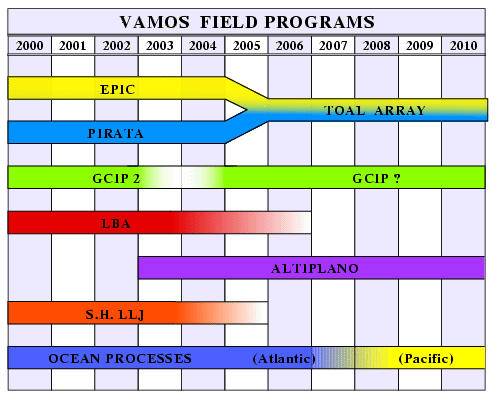
The VAMOS Panel current planning approach is based on phases, and addresses the problems of capacity building in data-void regions of the Americas. Figure 8 shows a preliminary timeline for VAMOS programmes. At its first meeting, the Panel decided:
The Panel appointed 5 working groups to contribute to the CVP1 report and to the initial stages of VAMOS planning. The terms of reference of these working groups are given in the next subsection of this report.
b) Terms of reference for VAMOS working groups and proposed membership
1. Process Studies Working Group
The VAMOS Process Studies Working Group shall assist over the next year in developing the initial plans for VAMOS process studies. It is responsible to the CLIVAR VAMOS Panel, will have a limited lifetime, and is charged with assisting in the preparation of the Report on the VAMOS/PACS Workshop on Field Programmes. Specifically, with the target date for a draft workshop report of July 1, 1998 and for a final workshop report of September 1, 1998 in mind the VAMOS Process Studies Working Group shall: 1) collect information on field programmes now underway and likely to occur in the next several years that will be part of VAMOS or relevant to VAMOS; 2) develop recommendations and initial plans for the next series of VAMOS process studies, those likely to occur in 2002-2005; and 3) develop a strategy for fostering the planning and consideration of future process studies. A procedure by which future process studies a policy for the exchange of data by VAMOS investigators. The working group will collate the information about planned process studies and summarize the scientific objectives, timing, location, and observational elements of planned process studies. It should also look for opportunities where cooperation and collaboration among planned programs and/or additional observational elements would enhance their value to VAMOS and include recommendations about such enhancements in their summary report. The working group will provide this report to the workshop organizers, C. Nobre and R. Weller, for inclusion the workshop report.
Membership: Eriksen, Campos, Lawford, M. Silva Dias, Weller (chair)
2. Data Working Group
The VAMOS Data Working Group shall assist in developing the initial plans and documents for VAMOS over the next year. It is responsible to the CLIVAR VAMOS Panel, will have a limited lifetime, and is charged with assisting in the preparation of the Report on the VAMOS/PACS Workshop on Field Programmes. Specifically, with the target date for a draft workshop report of July 1, 1998 and for a final workshop report of September 1, 1998 in mind the VAMOS Data Working Group shall: 1) identify data sets that will be of use in describing, understanding, and developing predictive skill for the variability of the American Monsoon System; 2) develop plans to make these data sets and other to be collected during VAMOS and related field programs readily available, including recommendations for digitization of previously collected data and for archiving the data sets; and 3) develop a policy for the exchange of data by VAMOS investigators. The working group will provide the results of their efforts to address these three task to the workshop organizers, C. Nobre and R. Weller, for inclusion the workshop report.
Membership: LBA person, Leese, Magaña (chair), Barros, Servain, Meitlin
3. Sustained Measurements Working Group
The VAMOS Sustained Measurements Working Group shall assist over the next year in developing the initial plans for the sustained measurements to be made during VAMOS. It is responsible to the CLIVAR VAMOS Panel, will have a limited lifetime, and is charged with assisting in the preparation of the Report on the VAMOS/PACS Workshop on Field Programmes. Specifically, with the target date for a draft workshop report of July 1, 1998 and for a final workshop report of September 1, 1998 in mind the VAMOS Sustained Measurements Working Group shall: 1) collect information on sustained observations now underway and likely to begin in the next several years that will be part of VAMOS or relevant to VAMOS and 2) develop recommendations and initial plans for new sustained measurements for VAMOS. The working group will collate the information about existing and recommended sustained measurements and summarize the scientific objectives, timing, location, and observational strategies of these programs. It should also look for opportunities where cooperation and collaboration among planned programs and/or additional observational elements would enhance their value to VAMOS and include recommendations about such enhancements in their summary report. The working group will provide this report to the workshop organizers, C. Nobre and R. Weller, for inclusion the workshop report.
Membership: Douglas, Wainer, Kousky (chair), Silva Dias, Weller, Enfield, Picaut, Mooers.
4. Stratus Working Group
The VAMOS Stratus Working Group is charged with developing cooperative, international research to investigate the role of stratus in the variability of the American monsoon systems. Over the next year it will assist in developing the initial plans for VAMOS field work and help in preparing the report on the CLIVAR/VAMOS Field Programmes Workshop. With the target date for a draft workshop report of July 1, 1998 and for a final workshop report of September 1, 1998 in mind the VAMOS Stratus Working Group will provide material for inclusion in the workshop report to co-chairs C. Nobre and R. Weller. After that it will continue to develop, organize, and foster cooperative stratus research within VAMOS. It is responsible to the CLIVAR VAMOS Panel, and plans for further development of stratus research initiatives should be approved by the CLIVAR/VAMOS Panel.
Membership: Soldi, Rogers, Albrecht (chair), Aceituno
5. South American Monsoon Working Group
The VAMOS South American Monsoon Working Group is charged with developing cooperative, international research to investigate the South American Monsoon system, including the low level jet. Over the next year it will assist in developing the initial plans for VAMOS field work and help in preparing the report on the CLIVAR/VAMOS Field Programmes Workshop. With the target date for a draft workshop report of July 1, 1998 and for a final workshop report of September 1, 1998 in mind the VAMOS South American Monsoon Working Group will provide material for inclusion in the workshop report to co-chairs C. Nobre and R. Weller. In 1998 it will develop plans for a workshop on the South American Monsoon and, with the approval of the CLIVAR/VAMOS Panel, organize and conduct that workshop. The goal of that workshop will be to develop the scientific objectives and plans for future research on the South American Monsoon. The working group will be responsible to the CLIVAR VAMOS Panel, and plans developed by the working group will need the approval of that panel.
Membership: Silva Dias (co-chair), Paegle (co-chair), Vera, Grimm, Aceituno, Kousky, Fu, Niccolini, Campos, Eriksen.
c) Critical dates and action items for VAMOS
XII. Acknowledgements
The CLIVAR-VAMOS Panel acknowledges the superb work by the Workshop Organizers R. Weller and C. Nobre and that of their committee members: M. Kayano and T. Ambrizzi. Dr. E. Campos was a perfect local organizer, which was a particularly demanding task in view of the multiple institutions and committees involved. The University of São Paulo provided the meeting space. Andreas Villwock has been a superb representative of CLIVARís International Project Office (IPO). S. Andrews at the University Corporation for Atmospheric Research (UCAR) handled many travel arrangements with her usual efficiency and friendliness.
XII. References
Absy, M.L, 1985: Palinology of Amazonia: The history of the forests as revealed by the palynological record. In: Amazonia. G. T. Prance and T. E. Lovejoy (eds.). Pergamon Press, Oxford, United Kingdom. 442 p.
Behling, H., 1996: First report on new evidence for the occurrence of Podocarpus and possible human presence of the Amazon during the Late-Glacial. Veget. Hist. Archeaeobot, 5, 241-246.
Behling, H., and M. Lichte, 1997: Evidence of dry and cold climatic conditions at Glacial times in tropical Southeastern Brazil. Quaternary Research, 48, 348-358.
Behling, H., 1998: Late quaternary vegetational and climatic changes in Brazil. Review of Palaeobotany and Palynology, 9, 143-156.
Clapperton, C., 1993: Nature of environmental changes inn South America at the last glacial maximum. Paleo, 101, 189-208.
Dapozzo, I. J., 1995: Influence of the Andes in the local circulations in Peru. Ms. Dissertation, Institute of Astronomy and Geophysics, University of São Paulo, Brazil.
Freitas, S. R., K. M. Longa, M. F. Silva Dias and P. Artaxo, 1996: Numerical modelling of the air mass trajectories from the biomass burning areas of the Amazon Basin. An. Acad. Bras. Ci., 68, 193-206.
Higgins, R. W., Y. Yao, E. S. Yarosh, J. E. Janowiak and K. C. Mo, 1997a: Influence of the Great Plains low-level jet on summertime precipitation and moisture transport over the central United States. J. Climate, 10, 481-507.
Higgins, R. W., Y. Yao and X. Wang, 1997b: Influence of the North American Monsoon System on the U.S. Summer Precipitation Regime. J. Climate, 10, 2600-2622.
Ledru, M. P. 1993: Late quaternary environmental and climatic changes in Central Brazil. Quaternary Research, 39, 90-98.
Ledru, M. P., H. Behling, M. Fournier, L. Martin and M. Servant, 1994: Localisation de la forêt díÁraucaria du Brésil au cours de l'Holocene. Implications paléoclimatiques. C.R. Acad. Sci. Paris, Sciences de la Vie/Life Sciences, 317, 527-521.
Ledru, M. P., M. Salgado-Labouriau and M. Lorscheitter, 1997: Vegetation dynamics in southern and central Brazil during the last 10,000 years BP. Review of Paleobotany and Palynology, submitted.
Marengo, J., 1995: Variations and change in South American stream flow. Climate Change, 31, 99-117.
Marengo, J., A. Cornejo, P. Satyamurty, C. A. Nobre and W. Sea, 1997: Cold waves in the South American continent: The strong event of June 1994. Mon. Wea. Rev., 125, 2759-2786.
Marengo, J., R. Victoria, V. Ballester, J. Tomasella, L. Campos, J. Cavalcxanti, H. Hoff, J. Newcomer, M. Padovan, M. dos Reis, R. dos Santos Alvala, N. Filizola, J. Guyot, M. Gracia and F. Gerab, 1998: Pre-LBA Data Sets Initiative CD ROMs, Vols. 1-3. CPTEC/INPE, Cacheoira Paulista, Sao Paulo, Brazil.
Marengo, J., J. Tomasella and C. Uvo, 1998: Trends in streamflow and rainfall in tropical South America: Amazonia, eastern Brazil, and northwestern Peru. J. Geogr. Research, 103, 1775-1783.
Martin, L., J. Bertaux, T. Cirrege, M. P. Ledru, P. Mourguiart, A. Sifeddine, F. Soubies, D. Wirrmann, K. Seguio and B. Turcq, 1997: Astronomical forcing of contrasting rainfall changes in tropical South America between 12,400 and 8,000 year B.P. Quaternary Research, 47, 117-122.
Mechoso, C. R., A. W. Robertson, N. Barth, M. K. Davey, P. Delecluse, P. R. Gent, S. Ineson, B. Kirtman, M. Latif, H. Le Treut, T. Nagai, J. D. Neelin, S. G. H. Philander, J. Polcher, P. S. Schopf, T. Stockdale, M. J. Suarez, L. Terray, O. Thual and J. J. Tribbia, 1995: The seasonal cycle over the Tropical Pacific in General Circulation Models. Mon. Wea. Rev., 123, 2825-2838.
Nobre, C. A., A. J. Dolman, J. H. C. Gash, R. W. A. Hutjes, D. J. Jacob, A. C. Janetos, P. Kabat, M. Keller, J. A. Marengo, R. J. McNeal, J. Melillo, P. J. Sellers, D. E. Wickland and S. C. Wofsy, 1996: The LBA Concise Experimental Plan. SCDLO - The Netherlands.
Robertson, A. W., C. R. Mechoso and Y.-J. Kim, 1998: The influence of Atlantic sea surface temperature anomalies on the North Atlantic Oscillation. J. Climate, submitted.
SALSA, Dr. Bruce F. Goff, Coordinator, Semi-Arid Land-Surface-Atmosphere (SALSA). USDA ARS Southwest Watershed Research Center. 2000 E. Allen Road. Tucson, AZ 85719, USA. phone:+520-670-6380x149/fax:+520-670-5550 email: bgoff@tucson.ars.ag.gov
Servain, J. 1991: Simple climatic indices for the Tropical Atlantic ocean with some applications. J. Geogr. Research, 96, 15137-15146.
Servant, M., J. Maley, B. Turcq, M. L. Absy, P. Brenac, M. Fournier and M.-P. Ledru, 1993: Tropical forests changes during the late quaternary in African and South American lowlands. Global and Planetary Change, 7, 25-40.
![]() To the TOP
To the TOP
![]() Back to the Table of Contents
Back to the Table of Contents